You are here: Home > Network List > TX - Texas Seismological Network Stations List
> Station HNDO Hondo > Earthquake Result Viewer
HNDO Hondo - Earthquake Result Viewer
| Earthquake location: |
Northern Chile |
| Earthquake latitude/longitude: |
-21.4/-69.9 |
| Earthquake time(UTC): |
2020/09/11 (255) 07:35:57 GMT |
| Earthquake Depth: |
51 km |
| Earthquake Magnitude: |
6.3 Mww |
| Earthquake Catalog/Contributor: |
NEIC PDE/us |
|
| Network: |
TX Texas Seismological Network |
| Station: |
HNDO Hondo |
| Lat/Lon: |
29.53 N/99.28 W |
| Elevation: |
381 m |
|
| Distance: |
58.0 deg |
| Az: |
329.718 deg |
| Baz: |
147.37 deg |
| Ray Param: |
0.06300917 |
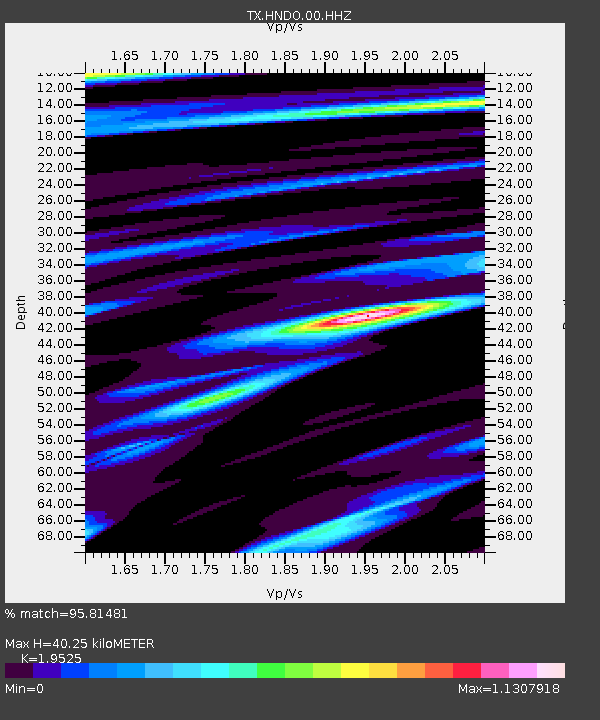
| Estimated Moho Depth: |
40.25 km |
| Estimated Crust Vp/Vs: |
1.95 |
| Assumed Crust Vp: |
6.347 km/s |
| Estimated Crust Vs: |
3.251 km/s |
| Estimated Crust Poisson's Ratio: |
0.32 |
|
| Radial Match: |
95.81481 % |
| Radial Bump: |
400 |
| Transverse Match: |
87.6912 % |
| Transverse Bump: |
378 |
| SOD ConfigId: |
22732711 |
| Insert Time: |
2020-09-25 08:02:12.472 +0000 |
| GWidth: |
2.5 |
| Max Bumps: |
400 |
| Tol: |
0.001 |
|

Signal To Noise
| Channel | StoN | STA | LTA |
| TX:HNDO:00:HHZ:20200911T07:45:14.740008Z | 17.706083 | 1.4091797E-6 | 7.9587316E-8 |
| TX:HNDO:00:HH1:20200911T07:45:14.740008Z | 3.1769893 | 2.337823E-7 | 7.3586115E-8 |
| TX:HNDO:00:HH2:20200911T07:45:14.740008Z | 8.89165 | 6.6494175E-7 | 7.478271E-8 |
| Arrivals |
| Ps | 6.3 SECOND |
| PpPs | 18 SECOND |
| PsPs/PpSs | 24 SECOND |


