You are here: Home > Network List > US - United States National Seismic Network Stations List
> Station HDIL Hopedale, Illinois, USA > Earthquake Result Viewer
HDIL Hopedale, Illinois, USA - Earthquake Result Viewer
| Earthquake location: |
Northern Chile |
| Earthquake latitude/longitude: |
-21.4/-69.9 |
| Earthquake time(UTC): |
2020/09/11 (255) 07:35:57 GMT |
| Earthquake Depth: |
51 km |
| Earthquake Magnitude: |
6.3 Mww |
| Earthquake Catalog/Contributor: |
NEIC PDE/us |
|
| Network: |
US United States National Seismic Network |
| Station: |
HDIL Hopedale, Illinois, USA |
| Lat/Lon: |
40.56 N/89.29 W |
| Elevation: |
219 m |
|
| Distance: |
64.2 deg |
| Az: |
343.677 deg |
| Baz: |
159.894 deg |
| Ray Param: |
0.058949787 |
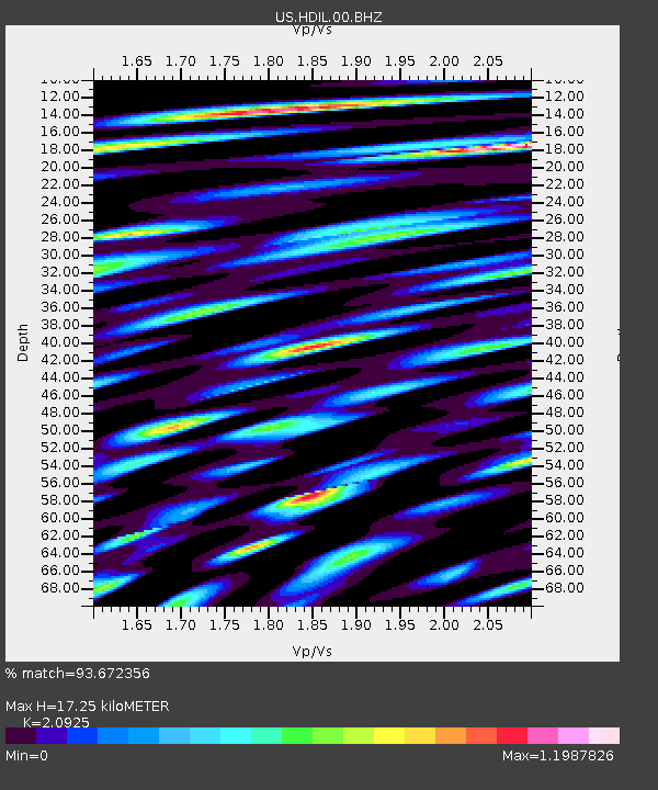
| Estimated Moho Depth: |
17.25 km |
| Estimated Crust Vp/Vs: |
2.09 |
| Assumed Crust Vp: |
6.498 km/s |
| Estimated Crust Vs: |
3.105 km/s |
| Estimated Crust Poisson's Ratio: |
0.35 |
|
| Radial Match: |
93.672356 % |
| Radial Bump: |
400 |
| Transverse Match: |
86.984566 % |
| Transverse Bump: |
400 |
| SOD ConfigId: |
22732711 |
| Insert Time: |
2020-09-25 08:04:47.414 +0000 |
| GWidth: |
2.5 |
| Max Bumps: |
400 |
| Tol: |
0.001 |
|

Signal To Noise
| Channel | StoN | STA | LTA |
| US:HDIL:00:BHZ:20200911T07:45:56.774005Z | 3.1995945 | 6.030503E-7 | 1.884771E-7 |
| US:HDIL:00:BH1:20200911T07:45:56.774005Z | 3.8850439 | 7.110176E-7 | 1.8301405E-7 |
| US:HDIL:00:BH2:20200911T07:45:56.774005Z | 2.8387804 | 3.9316217E-7 | 1.3849687E-7 |
| Arrivals |
| Ps | 3.0 SECOND |
| PpPs | 7.9 SECOND |
| PsPs/PpSs | 11 SECOND |


