You are here: Home > Network List > AT - Alaska Tsunami Warning Seismic System Stations List
> Station AKUT Akutan, Alaska > Earthquake Result Viewer
AKUT Akutan, Alaska - Earthquake Result Viewer
| Earthquake location: |
Tonga Islands |
| Earthquake latitude/longitude: |
-15.8/-173.1 |
| Earthquake time(UTC): |
2009/09/29 (272) 17:57:26 GMT |
| Earthquake Depth: |
10 km |
| Earthquake Magnitude: |
5.6 MB |
| Earthquake Catalog/Contributor: |
WHDF/NEIC |
|
| Network: |
AT Alaska Tsunami Warning Seismic System |
| Station: |
AKUT Akutan, Alaska |
| Lat/Lon: |
54.14 N/165.77 W |
| Elevation: |
19 m |
|
| Distance: |
70.0 deg |
| Az: |
4.599 deg |
| Baz: |
187.537 deg |
| Ray Param: |
0.05530455 |
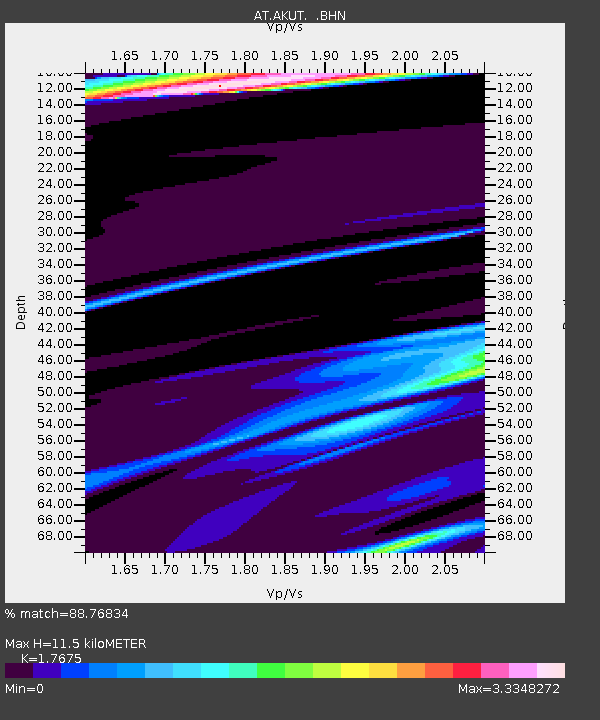
| Estimated Moho Depth: |
11.5 km |
| Estimated Crust Vp/Vs: |
1.77 |
| Assumed Crust Vp: |
5.989 km/s |
| Estimated Crust Vs: |
3.388 km/s |
| Estimated Crust Poisson's Ratio: |
0.26 |
|
| Radial Match: |
88.76834 % |
| Radial Bump: |
400 |
| Transverse Match: |
66.8235 % |
| Transverse Bump: |
400 |
| SOD ConfigId: |
2622 |
| Insert Time: |
2010-03-09 01:07:27.652 +0000 |
| GWidth: |
2.5 |
| Max Bumps: |
400 |
| Tol: |
0.001 |
|

Signal To Noise
| Channel | StoN | STA | LTA |
| AT:AKUT: :BHN:20090929T18:08:07.080015Z | 1.5868516 | 8.390197E-6 | 5.287323E-6 |
| AT:AKUT: :BHE:20090929T18:08:07.080015Z | 1.2677683 | 1.4944397E-5 | 1.1787957E-5 |
| AT:AKUT: :BHZ:20090929T18:08:07.080015Z | 2.397072 | 1.6471187E-5 | 6.871377E-6 |
| Arrivals |
| Ps | 1.5 SECOND |
| PpPs | 5.1 SECOND |
| PsPs/PpSs | 6.7 SECOND |


