You are here: Home > Network List > AT - Alaska Tsunami Warning Seismic System Stations List
> Station AKUT Akutan, Alaska > Earthquake Result Viewer
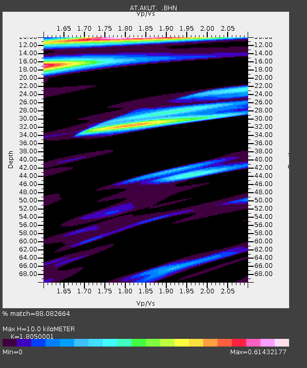
AKUT Akutan, Alaska - Earthquake Result Viewer
| Earthquake location: |
Tonga Islands |
| Earthquake latitude/longitude: |
-20.2/-174.1 |
| Earthquake time(UTC): |
2006/05/03 (123) 15:26:40 GMT |
| Earthquake Depth: |
55 km |
| Earthquake Magnitude: |
7.2 MB, 7.8 MS, 7.9 MW, 7.9 MW |
| Earthquake Catalog/Contributor: |
WHDF/NEIC |
|
| Network: |
AT Alaska Tsunami Warning Seismic System |
| Station: |
AKUT Akutan, Alaska |
| Lat/Lon: |
54.14 N/165.77 W |
| Elevation: |
19 m |
|
| Distance: |
74.4 deg |
| Az: |
5.092 deg |
| Baz: |
188.144 deg |
| Ray Param: |
0.05227398 |
| Estimated Moho Depth: |
10.0 km |
| Estimated Crust Vp/Vs: |
1.81 |
| Assumed Crust Vp: |
5.989 km/s |
| Estimated Crust Vs: |
3.318 km/s |
| Estimated Crust Poisson's Ratio: |
0.28 |
|
| Radial Match: |
88.082664 % |
| Radial Bump: |
399 |
| Transverse Match: |
85.70973 % |
| Transverse Bump: |
400 |
| SOD ConfigId: |
2669 |
| Insert Time: |
2010-03-09 01:07:30.110 +0000 |
| GWidth: |
2.5 |
| Max Bumps: |
400 |
| Tol: |
0.001 |
|

Signal To Noise
| Channel | StoN | STA | LTA |
| AT:AKUT: :BHN:20060503T15:37:41.219016Z | 7.867323 | 5.974774E-6 | 7.594418E-7 |
| AT:AKUT: :BHE:20060503T15:37:41.219016Z | 3.769209 | 2.2235065E-6 | 5.899133E-7 |
| AT:AKUT: :BHZ:20060503T15:37:41.219016Z | 16.960407 | 1.5434316E-5 | 9.100204E-7 |
| Arrivals |
| Ps | 1.4 SECOND |
| PpPs | 4.6 SECOND |
| PsPs/PpSs | 5.9 SECOND |


