You are here: Home > Network List > WY - Yellowstone Wyoming Seismic Network Stations List
> Station YNR Norris Junction, YNP, WY, USA > Earthquake Result Viewer
YNR Norris Junction, YNP, WY, USA - Earthquake Result Viewer
| Earthquake location: |
Northern Chile |
| Earthquake latitude/longitude: |
-21.4/-69.9 |
| Earthquake time(UTC): |
2020/09/11 (255) 07:35:57 GMT |
| Earthquake Depth: |
51 km |
| Earthquake Magnitude: |
6.3 Mww |
| Earthquake Catalog/Contributor: |
NEIC PDE/us |
|
| Network: |
WY Yellowstone Wyoming Seismic Network |
| Station: |
YNR Norris Junction, YNP, WY, USA |
| Lat/Lon: |
44.72 N/110.68 W |
| Elevation: |
2336 m |
|
| Distance: |
75.6 deg |
| Az: |
331.259 deg |
| Baz: |
141.059 deg |
| Ray Param: |
0.051474992 |
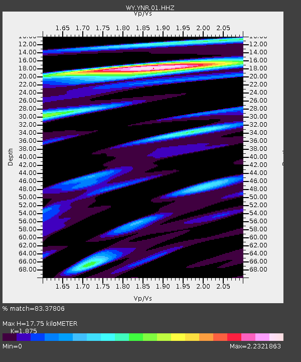
| Estimated Moho Depth: |
17.75 km |
| Estimated Crust Vp/Vs: |
1.88 |
| Assumed Crust Vp: |
6.35 km/s |
| Estimated Crust Vs: |
3.387 km/s |
| Estimated Crust Poisson's Ratio: |
0.30 |
|
| Radial Match: |
83.37806 % |
| Radial Bump: |
400 |
| Transverse Match: |
80.19653 % |
| Transverse Bump: |
400 |
| SOD ConfigId: |
22732711 |
| Insert Time: |
2020-09-25 08:09:05.056 +0000 |
| GWidth: |
2.5 |
| Max Bumps: |
400 |
| Tol: |
0.001 |
|
Signal To Noise
| Channel | StoN | STA | LTA |
| WY:YNR:01:HHZ:20200911T07:47:06.347979Z | 13.7632675 | 3.0749316E-8 | 2.234158E-9 |
| WY:YNR:01:HHN:20200911T07:47:06.347979Z | 5.3732057 | 1.7764014E-8 | 3.3060368E-9 |
| WY:YNR:01:HHE:20200911T07:47:06.347979Z | 11.289446 | 2.3080592E-8 | 2.0444397E-9 |
| Arrivals |
| Ps | 2.5 SECOND |
| PpPs | 7.8 SECOND |
| PsPs/PpSs | 10 SECOND |


