You are here: Home > Network List > IU - Global Seismograph Network (GSN - IRIS/USGS) Stations List
> Station FURI Mt. Furi, Ethiopia > Earthquake Result Viewer
FURI Mt. Furi, Ethiopia - Earthquake Result Viewer
*The percent match for this event was below the threshold and hence no stack was calculated.
| Earthquake location: |
Luzon, Philippines |
| Earthquake latitude/longitude: |
14.0/120.7 |
| Earthquake time(UTC): |
2017/08/11 (223) 05:28:25 GMT |
| Earthquake Depth: |
168 km |
| Earthquake Magnitude: |
6.2 Mww |
| Earthquake Catalog/Contributor: |
NEIC PDE/us |
|
| Network: |
IU Global Seismograph Network (GSN - IRIS/USGS) |
| Station: |
FURI Mt. Furi, Ethiopia |
| Lat/Lon: |
8.90 N/38.68 E |
| Elevation: |
2570 m |
|
| Distance: |
80.2 deg |
| Az: |
276.769 deg |
| Baz: |
77.281 deg |
| Ray Param: |
$rayparam |
*The percent match for this event was below the threshold and hence was not used in the summary stack. |
|
| Radial Match: |
74.39986 % |
| Radial Bump: |
400 |
| Transverse Match: |
71.56626 % |
| Transverse Bump: |
400 |
| SOD ConfigId: |
2140511 |
| Insert Time: |
2017-08-24 21:24:33.523 +0000 |
| GWidth: |
2.5 |
| Max Bumps: |
400 |
| Tol: |
0.001 |
|
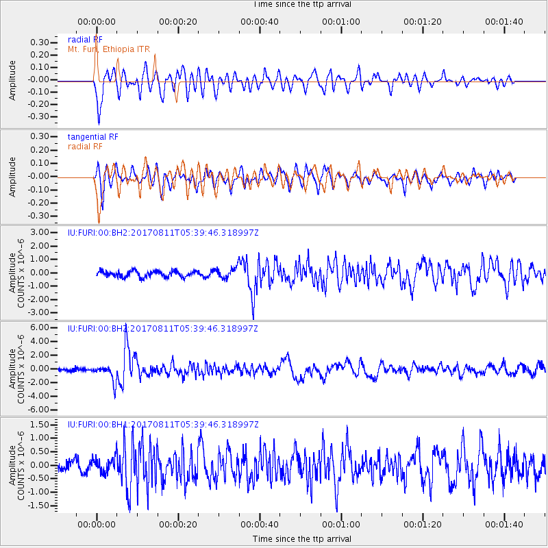
Signal To Noise
| Channel | StoN | STA | LTA |
| IU:FURI:00:BHZ:20170811T05:39:46.318997Z | 5.228839 | 1.2153704E-6 | 2.32436E-7 |
| IU:FURI:00:BH1:20170811T05:39:46.318997Z | 1.4647732 | 2.8815492E-7 | 1.9672324E-7 |
| IU:FURI:00:BH2:20170811T05:39:46.318997Z | 1.7603256 | 4.0206055E-7 | 2.2840125E-7 |
| Arrivals |
| Ps | |
| PpPs | |
| PsPs/PpSs | |


