You are here: Home > Network List > IU - Global Seismograph Network (GSN - IRIS/USGS) Stations List
> Station PMG Port Moresby, New Guinea > Earthquake Result Viewer
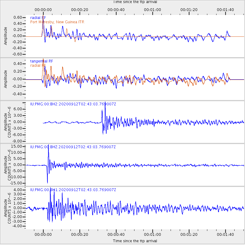
PMG Port Moresby, New Guinea - Earthquake Result Viewer
*The percent match for this event was below the threshold and hence no stack was calculated.
| Earthquake location: |
Fiji Islands Region |
| Earthquake latitude/longitude: |
-17.9/-178.1 |
| Earthquake time(UTC): |
2020/09/12 (256) 02:37:29 GMT |
| Earthquake Depth: |
557 km |
| Earthquake Magnitude: |
5.6 Mww |
| Earthquake Catalog/Contributor: |
NEIC PDE/us |
|
| Network: |
IU Global Seismograph Network (GSN - IRIS/USGS) |
| Station: |
PMG Port Moresby, New Guinea |
| Lat/Lon: |
9.40 S/147.16 E |
| Elevation: |
90 m |
|
| Distance: |
34.8 deg |
| Az: |
279.353 deg |
| Baz: |
107.774 deg |
| Ray Param: |
$rayparam |
*The percent match for this event was below the threshold and hence was not used in the summary stack. |
|
| Radial Match: |
85.073265 % |
| Radial Bump: |
400 |
| Transverse Match: |
83.65926 % |
| Transverse Bump: |
400 |
| SOD ConfigId: |
22732711 |
| Insert Time: |
2020-09-26 02:47:56.138 +0000 |
| GWidth: |
2.5 |
| Max Bumps: |
400 |
| Tol: |
0.001 |
|
Signal To Noise
| Channel | StoN | STA | LTA |
| IU:PMG:00:BHZ:20200912T02:43:03.769007Z | 31.30767 | 5.0144813E-6 | 1.6016782E-7 |
| IU:PMG:00:BH1:20200912T02:43:03.769007Z | 7.2344646 | 1.2889822E-6 | 1.7817243E-7 |
| IU:PMG:00:BH2:20200912T02:43:03.769007Z | 13.015479 | 2.8683528E-6 | 2.2038012E-7 |
| Arrivals |
| Ps | |
| PpPs | |
| PsPs/PpSs | |


