You are here: Home > Network List > TA - USArray Transportable Network (new EarthScope stations) Stations List
> Station E18K Tukpahlearik Creek, AK, USA > Earthquake Result Viewer
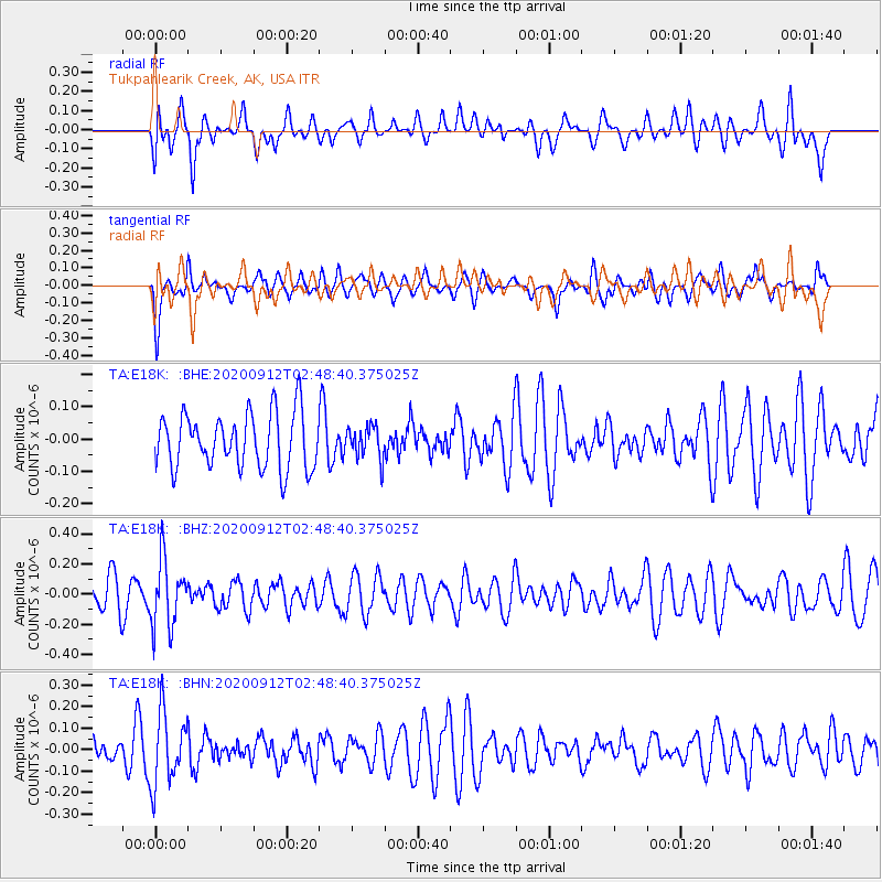
E18K Tukpahlearik Creek, AK, USA - Earthquake Result Viewer
*The percent match for this event was below the threshold and hence no stack was calculated.
| Earthquake location: |
Fiji Islands Region |
| Earthquake latitude/longitude: |
-17.9/-178.1 |
| Earthquake time(UTC): |
2020/09/12 (256) 02:37:29 GMT |
| Earthquake Depth: |
557 km |
| Earthquake Magnitude: |
5.6 Mww |
| Earthquake Catalog/Contributor: |
NEIC PDE/us |
|
| Network: |
TA USArray Transportable Network (new EarthScope stations) |
| Station: |
E18K Tukpahlearik Creek, AK, USA |
| Lat/Lon: |
67.42 N/160.60 W |
| Elevation: |
297 m |
|
| Distance: |
86.0 deg |
| Az: |
6.666 deg |
| Baz: |
196.636 deg |
| Ray Param: |
$rayparam |
*The percent match for this event was below the threshold and hence was not used in the summary stack. |
|
| Radial Match: |
56.634872 % |
| Radial Bump: |
400 |
| Transverse Match: |
57.19378 % |
| Transverse Bump: |
357 |
| SOD ConfigId: |
22732711 |
| Insert Time: |
2020-09-26 02:51:50.781 +0000 |
| GWidth: |
2.5 |
| Max Bumps: |
400 |
| Tol: |
0.001 |
|
Signal To Noise
| Channel | StoN | STA | LTA |
| TA:E18K: :BHZ:20200912T02:48:40.375025Z | 2.5799859 | 2.208058E-7 | 8.558412E-8 |
| TA:E18K: :BHN:20200912T02:48:40.375025Z | 1.7222469 | 1.668455E-7 | 9.687664E-8 |
| TA:E18K: :BHE:20200912T02:48:40.375025Z | 0.5830276 | 4.9906156E-8 | 8.559827E-8 |
| Arrivals |
| Ps | |
| PpPs | |
| PsPs/PpSs | |


