You are here: Home > Network List > TA - USArray Transportable Network (new EarthScope stations) Stations List
> Station M16K Timber Creek, AK, USA > Earthquake Result Viewer
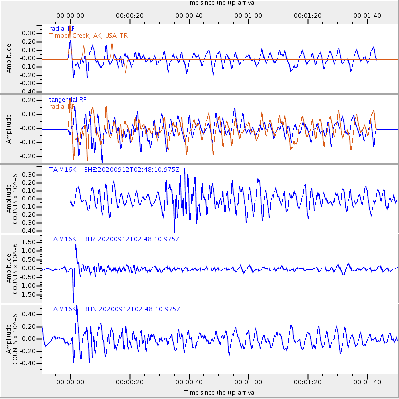
M16K Timber Creek, AK, USA - Earthquake Result Viewer
*The percent match for this event was below the threshold and hence no stack was calculated.
| Earthquake location: |
Fiji Islands Region |
| Earthquake latitude/longitude: |
-17.9/-178.1 |
| Earthquake time(UTC): |
2020/09/12 (256) 02:37:29 GMT |
| Earthquake Depth: |
557 km |
| Earthquake Magnitude: |
5.6 Mww |
| Earthquake Catalog/Contributor: |
NEIC PDE/us |
|
| Network: |
TA USArray Transportable Network (new EarthScope stations) |
| Station: |
M16K Timber Creek, AK, USA |
| Lat/Lon: |
61.02 N/158.96 W |
| Elevation: |
394 m |
|
| Distance: |
80.1 deg |
| Az: |
9.306 deg |
| Baz: |
198.435 deg |
| Ray Param: |
$rayparam |
*The percent match for this event was below the threshold and hence was not used in the summary stack. |
|
| Radial Match: |
57.360603 % |
| Radial Bump: |
400 |
| Transverse Match: |
64.733315 % |
| Transverse Bump: |
400 |
| SOD ConfigId: |
22732711 |
| Insert Time: |
2020-09-26 02:52:53.035 +0000 |
| GWidth: |
2.5 |
| Max Bumps: |
400 |
| Tol: |
0.001 |
|
Signal To Noise
| Channel | StoN | STA | LTA |
| TA:M16K: :BHZ:20200912T02:48:10.975Z | 7.7074237 | 6.0972786E-7 | 7.910917E-8 |
| TA:M16K: :BHN:20200912T02:48:10.975Z | 1.9586953 | 2.2037952E-7 | 1.12513426E-7 |
| TA:M16K: :BHE:20200912T02:48:10.975Z | 1.3103104 | 1.233185E-7 | 9.411396E-8 |
| Arrivals |
| Ps | |
| PpPs | |
| PsPs/PpSs | |


