You are here: Home > Network List > AT - Alaska Tsunami Warning Seismic System Stations List
> Station OHAK Old Harbor, Alaska > Earthquake Result Viewer
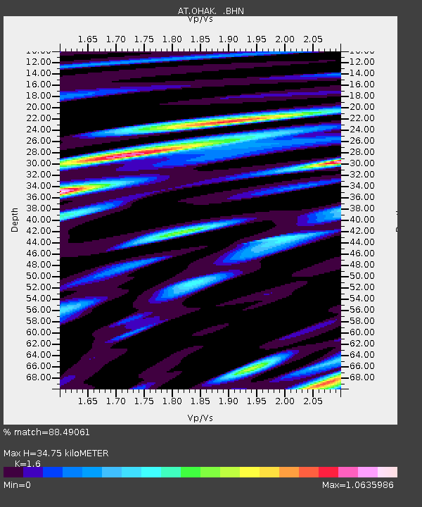
OHAK Old Harbor, Alaska - Earthquake Result Viewer
| Earthquake location: |
Peru-Brazil Border Region |
| Earthquake latitude/longitude: |
-7.6/-74.4 |
| Earthquake time(UTC): |
2008/08/26 (239) 21:00:36 GMT |
| Earthquake Depth: |
154 km |
| Earthquake Magnitude: |
6.0 MB, 6.4 MW, 6.4 MW |
| Earthquake Catalog/Contributor: |
WHDF/NEIC |
|
| Network: |
AT Alaska Tsunami Warning Seismic System |
| Station: |
OHAK Old Harbor, Alaska |
| Lat/Lon: |
57.22 N/153.29 W |
| Elevation: |
78 m |
|
| Distance: |
90.4 deg |
| Az: |
327.737 deg |
| Baz: |
103.405 deg |
| Ray Param: |
0.041643053 |
| Estimated Moho Depth: |
34.75 km |
| Estimated Crust Vp/Vs: |
1.60 |
| Assumed Crust Vp: |
6.134 km/s |
| Estimated Crust Vs: |
3.834 km/s |
| Estimated Crust Poisson's Ratio: |
0.18 |
|
| Radial Match: |
88.49061 % |
| Radial Bump: |
400 |
| Transverse Match: |
76.066154 % |
| Transverse Bump: |
400 |
| SOD ConfigId: |
2504 |
| Insert Time: |
2010-03-09 01:09:34.848 +0000 |
| GWidth: |
2.5 |
| Max Bumps: |
400 |
| Tol: |
0.001 |
|

Signal To Noise
| Channel | StoN | STA | LTA |
| AT:OHAK: :BHN:20080826T21:12:49.260024Z | 15.41961 | 1.9580734E-6 | 1.2698592E-7 |
| AT:OHAK: :BHE:20080826T21:12:49.260024Z | 0.7901493 | 1.2215382E-7 | 1.545959E-7 |
| AT:OHAK: :BHZ:20080826T21:12:49.260024Z | 4.237144 | 5.0185554E-7 | 1.18441946E-7 |
| Arrivals |
| Ps | 3.5 SECOND |
| PpPs | 14 SECOND |
| PsPs/PpSs | 18 SECOND |


