You are here: Home > Network List > AK - Alaska Regional Network Stations List
> Station S31K Pelican, AK, USA > Earthquake Result Viewer
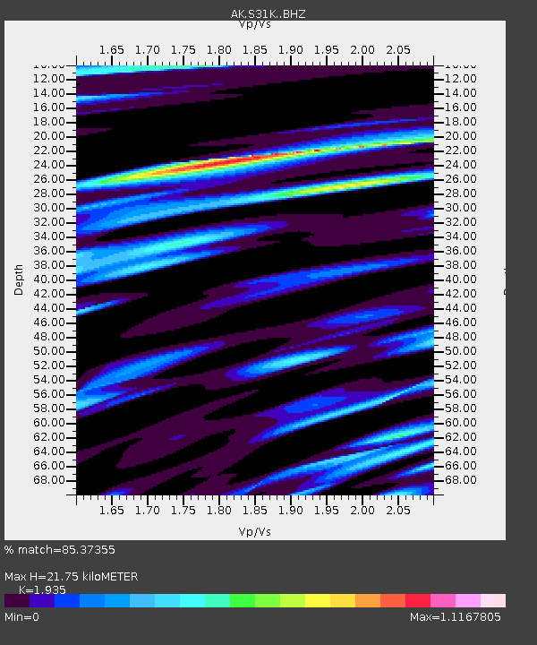
S31K Pelican, AK, USA - Earthquake Result Viewer
| Earthquake location: |
Near East Coast Of Honshu, Japan |
| Earthquake latitude/longitude: |
38.8/142.2 |
| Earthquake time(UTC): |
2020/09/12 (256) 02:44:10 GMT |
| Earthquake Depth: |
32 km |
| Earthquake Magnitude: |
6.1 mww |
| Earthquake Catalog/Contributor: |
NEIC PDE/us |
|
| Network: |
AK Alaska Regional Network |
| Station: |
S31K Pelican, AK, USA |
| Lat/Lon: |
57.96 N/136.23 W |
| Elevation: |
34 m |
|
| Distance: |
53.9 deg |
| Az: |
40.721 deg |
| Baz: |
286.891 deg |
| Ray Param: |
0.06572104 |
| Estimated Moho Depth: |
21.75 km |
| Estimated Crust Vp/Vs: |
1.93 |
| Assumed Crust Vp: |
6.134 km/s |
| Estimated Crust Vs: |
3.17 km/s |
| Estimated Crust Poisson's Ratio: |
0.32 |
|
| Radial Match: |
85.37355 % |
| Radial Bump: |
400 |
| Transverse Match: |
74.72811 % |
| Transverse Bump: |
400 |
| SOD ConfigId: |
22732711 |
| Insert Time: |
2020-09-26 02:59:22.073 +0000 |
| GWidth: |
2.5 |
| Max Bumps: |
400 |
| Tol: |
0.001 |
|

Signal To Noise
| Channel | StoN | STA | LTA |
| AK:S31K: :BHZ:20200912T02:53:00.640021Z | 3.1433287 | 3.046552E-7 | 9.6921205E-8 |
| AK:S31K: :BHN:20200912T02:53:00.640021Z | 1.2535613 | 7.6995335E-8 | 6.142128E-8 |
| AK:S31K: :BHE:20200912T02:53:00.640021Z | 2.883555 | 2.1003169E-7 | 7.2837764E-8 |
| Arrivals |
| Ps | 3.5 SECOND |
| PpPs | 10.0 SECOND |
| PsPs/PpSs | 13 SECOND |


