You are here: Home > Network List > CC - Cascade Chain Volcano Monitoring Stations List
> Station PR01 Puyallup River 01 > Earthquake Result Viewer
PR01 Puyallup River 01 - Earthquake Result Viewer
| Earthquake location: |
Near East Coast Of Honshu, Japan |
| Earthquake latitude/longitude: |
38.8/142.2 |
| Earthquake time(UTC): |
2020/09/12 (256) 02:44:10 GMT |
| Earthquake Depth: |
32 km |
| Earthquake Magnitude: |
6.1 mww |
| Earthquake Catalog/Contributor: |
NEIC PDE/us |
|
| Network: |
CC Cascade Chain Volcano Monitoring |
| Station: |
PR01 Puyallup River 01 |
| Lat/Lon: |
46.91 N/122.04 W |
| Elevation: |
648 m |
|
| Distance: |
66.4 deg |
| Az: |
48.116 deg |
| Baz: |
301.895 deg |
| Ray Param: |
0.057598766 |
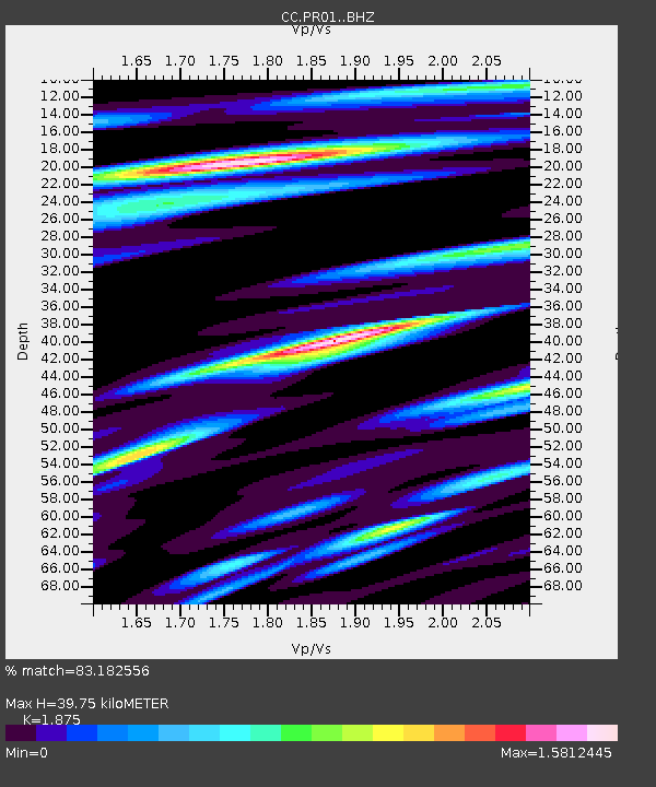
| Estimated Moho Depth: |
39.75 km |
| Estimated Crust Vp/Vs: |
1.88 |
| Assumed Crust Vp: |
6.566 km/s |
| Estimated Crust Vs: |
3.502 km/s |
| Estimated Crust Poisson's Ratio: |
0.30 |
|
| Radial Match: |
83.182556 % |
| Radial Bump: |
400 |
| Transverse Match: |
78.97077 % |
| Transverse Bump: |
400 |
| SOD ConfigId: |
22732711 |
| Insert Time: |
2020-09-26 03:03:31.692 +0000 |
| GWidth: |
2.5 |
| Max Bumps: |
400 |
| Tol: |
0.001 |
|

Signal To Noise
| Channel | StoN | STA | LTA |
| CC:PR01: :BHZ:20200912T02:54:25.90003Z | 5.4892187 | 3.5652607E-7 | 6.495024E-8 |
| CC:PR01: :BHN:20200912T02:54:25.90003Z | 1.4315797 | 1.15215435E-7 | 8.048133E-8 |
| CC:PR01: :BHE:20200912T02:54:25.90003Z | 1.4534926 | 1.3355907E-7 | 9.1888374E-8 |
| Arrivals |
| Ps | 5.5 SECOND |
| PpPs | 17 SECOND |
| PsPs/PpSs | 22 SECOND |


