You are here: Home > Network List > CC - Cascade Chain Volcano Monitoring Stations List
> Station SUG Sugar Bowl > Earthquake Result Viewer
SUG Sugar Bowl - Earthquake Result Viewer
| Earthquake location: |
Near East Coast Of Honshu, Japan |
| Earthquake latitude/longitude: |
38.8/142.2 |
| Earthquake time(UTC): |
2020/09/12 (256) 02:44:10 GMT |
| Earthquake Depth: |
32 km |
| Earthquake Magnitude: |
6.1 mww |
| Earthquake Catalog/Contributor: |
NEIC PDE/us |
|
| Network: |
CC Cascade Chain Volcano Monitoring |
| Station: |
SUG Sugar Bowl |
| Lat/Lon: |
46.22 N/122.18 W |
| Elevation: |
1859 m |
|
| Distance: |
66.7 deg |
| Az: |
48.814 deg |
| Baz: |
302.073 deg |
| Ray Param: |
0.05741127 |
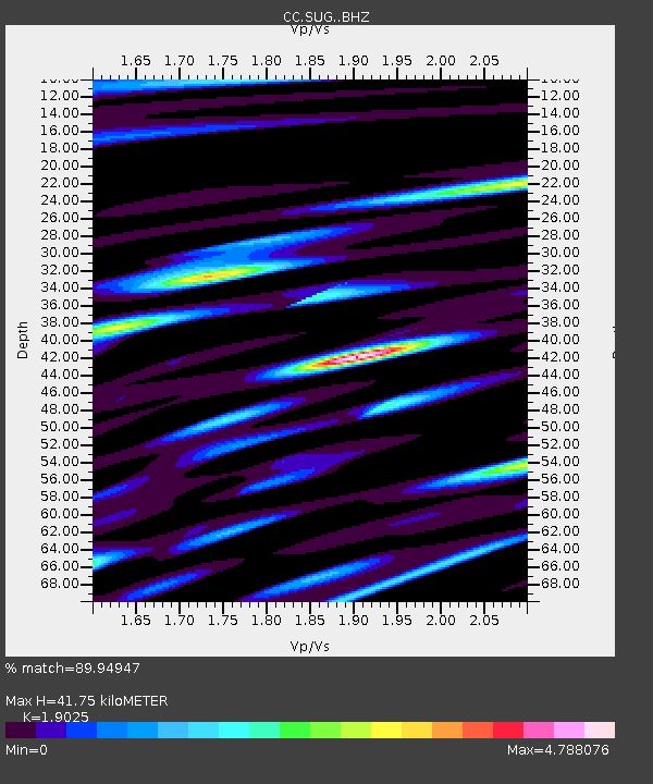
| Estimated Moho Depth: |
41.75 km |
| Estimated Crust Vp/Vs: |
1.90 |
| Assumed Crust Vp: |
6.566 km/s |
| Estimated Crust Vs: |
3.451 km/s |
| Estimated Crust Poisson's Ratio: |
0.31 |
|
| Radial Match: |
89.94947 % |
| Radial Bump: |
400 |
| Transverse Match: |
87.812294 % |
| Transverse Bump: |
400 |
| SOD ConfigId: |
22732711 |
| Insert Time: |
2020-09-26 03:03:45.688 +0000 |
| GWidth: |
2.5 |
| Max Bumps: |
400 |
| Tol: |
0.001 |
|

Signal To Noise
| Channel | StoN | STA | LTA |
| CC:SUG: :BHZ:20200912T02:54:27.719977Z | 4.967316 | 4.1773444E-7 | 8.409661E-8 |
| CC:SUG: :BHN:20200912T02:54:27.719977Z | 1.8504875 | 2.3202466E-7 | 1.253857E-7 |
| CC:SUG: :BHE:20200912T02:54:27.719977Z | 1.1689397 | 2.870845E-7 | 2.4559395E-7 |
| Arrivals |
| Ps | 6.0 SECOND |
| PpPs | 18 SECOND |
| PsPs/PpSs | 24 SECOND |


