You are here: Home > Network List > CI - Caltech Regional Seismic Network Stations List
> Station MPM Manuel Prospect Mine, California, USA > Earthquake Result Viewer
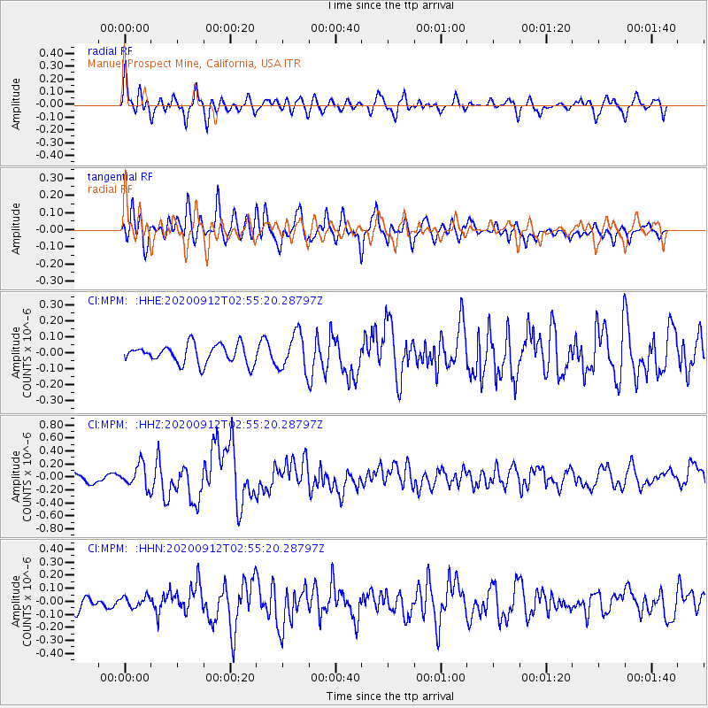
MPM Manuel Prospect Mine, California, USA - Earthquake Result Viewer
*The percent match for this event was below the threshold and hence no stack was calculated.
| Earthquake location: |
Near East Coast Of Honshu, Japan |
| Earthquake latitude/longitude: |
38.8/142.2 |
| Earthquake time(UTC): |
2020/09/12 (256) 02:44:10 GMT |
| Earthquake Depth: |
32 km |
| Earthquake Magnitude: |
6.1 mww |
| Earthquake Catalog/Contributor: |
NEIC PDE/us |
|
| Network: |
CI Caltech Regional Seismic Network |
| Station: |
MPM Manuel Prospect Mine, California, USA |
| Lat/Lon: |
36.06 N/117.49 W |
| Elevation: |
185 m |
|
| Distance: |
75.4 deg |
| Az: |
55.49 deg |
| Baz: |
307.337 deg |
| Ray Param: |
$rayparam |
*The percent match for this event was below the threshold and hence was not used in the summary stack. |
|
| Radial Match: |
70.40454 % |
| Radial Bump: |
400 |
| Transverse Match: |
71.83917 % |
| Transverse Bump: |
400 |
| SOD ConfigId: |
22732711 |
| Insert Time: |
2020-09-26 03:04:51.244 +0000 |
| GWidth: |
2.5 |
| Max Bumps: |
400 |
| Tol: |
0.001 |
|
Signal To Noise
| Channel | StoN | STA | LTA |
| CI:MPM: :HHZ:20200912T02:55:20.28797Z | 1.648521 | 1.7727686E-7 | 1.0753692E-7 |
| CI:MPM: :HHN:20200912T02:55:20.28797Z | 0.585052 | 4.029017E-8 | 6.8865965E-8 |
| CI:MPM: :HHE:20200912T02:55:20.28797Z | 1.977336 | 1.17056715E-7 | 5.9199202E-8 |
| Arrivals |
| Ps | |
| PpPs | |
| PsPs/PpSs | |


