You are here: Home > Network List > GS - US Geological Survey Networks Stations List
> Station ASA6 ASA6 > Earthquake Result Viewer
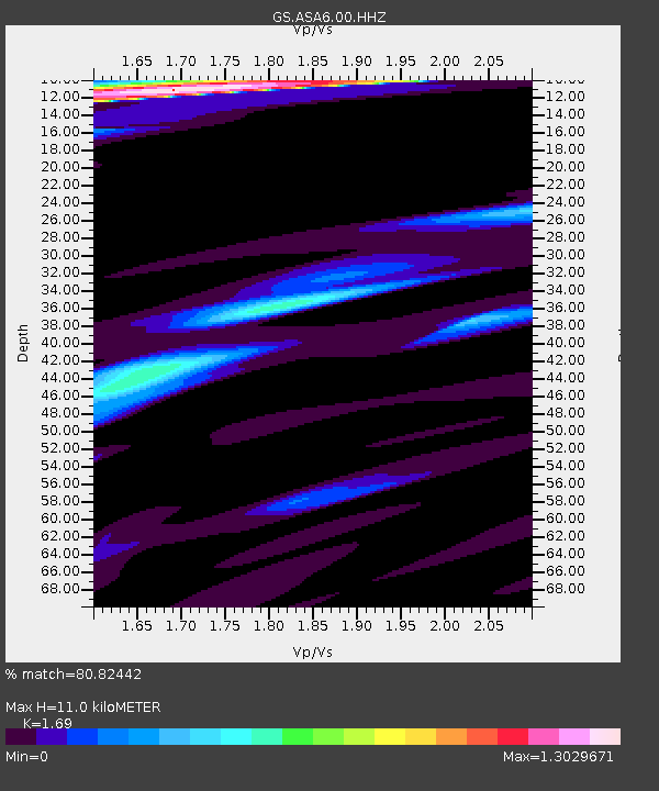
ASA6 ASA6 - Earthquake Result Viewer
| Earthquake location: |
Near East Coast Of Honshu, Japan |
| Earthquake latitude/longitude: |
38.8/142.2 |
| Earthquake time(UTC): |
2020/09/12 (256) 02:44:10 GMT |
| Earthquake Depth: |
32 km |
| Earthquake Magnitude: |
6.1 mww |
| Earthquake Catalog/Contributor: |
NEIC PDE/us |
|
| Network: |
GS US Geological Survey Networks |
| Station: |
ASA6 ASA6 |
| Lat/Lon: |
34.94 N/106.46 W |
| Elevation: |
1840 m |
|
| Distance: |
83.0 deg |
| Az: |
50.462 deg |
| Baz: |
312.781 deg |
| Ray Param: |
0.04647285 |
| Estimated Moho Depth: |
11.0 km |
| Estimated Crust Vp/Vs: |
1.69 |
| Assumed Crust Vp: |
6.502 km/s |
| Estimated Crust Vs: |
3.847 km/s |
| Estimated Crust Poisson's Ratio: |
0.23 |
|
| Radial Match: |
80.82442 % |
| Radial Bump: |
337 |
| Transverse Match: |
65.982346 % |
| Transverse Bump: |
400 |
| SOD ConfigId: |
22732711 |
| Insert Time: |
2020-09-26 03:09:29.436 +0000 |
| GWidth: |
2.5 |
| Max Bumps: |
400 |
| Tol: |
0.001 |
|

Signal To Noise
| Channel | StoN | STA | LTA |
| GS:ASA6:00:HHZ:20200912T02:56:01.669012Z | 5.188581 | 2.9486807E-7 | 5.68302E-8 |
| GS:ASA6:00:HH1:20200912T02:56:01.669012Z | 1.2744724 | 8.2287265E-8 | 6.456575E-8 |
| GS:ASA6:00:HH2:20200912T02:56:01.669012Z | 1.5264256 | 8.34674E-8 | 5.46816E-8 |
| Arrivals |
| Ps | 1.2 SECOND |
| PpPs | 4.4 SECOND |
| PsPs/PpSs | 5.6 SECOND |


