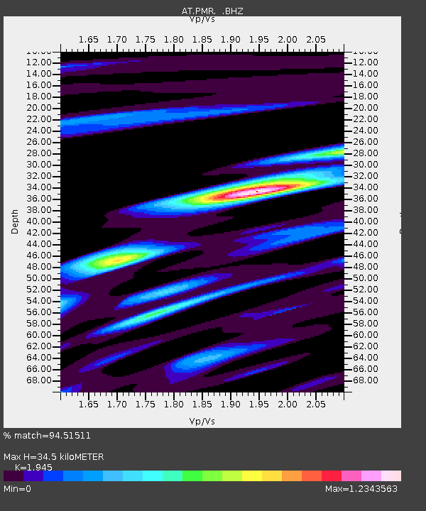
PMR Palmer, Alaska - Earthquake Result Viewer

Earthquake location: New Ireland Region, P.N.G.
Earthquake latitude/longitude: -3.4/150.5
Earthquake time(UTC): 2009/07/15 (196) 20:10:42 GMT
Earthquake Depth: 13 km
Earthquake Magnitude: 5.6 MB, 6.1 MS, 6.1 MW, 6.1 MW
Earthquake Catalog/Contributor: WHDF/NEIC
Network: AT Alaska Tsunami Warning Seismic System
Station: PMR Palmer, Alaska
Lat/Lon: 61.59 N/149.13 W
Elevation: 100 m
Distance: 79.4 deg
Az: 25.02 deg
Baz: 241.992 deg
Ray Param: 0.04901122
Estimated Moho Depth: 34.5 km
Estimated Crust Vp/Vs: 1.95
Assumed Crust Vp: 6.566 km/s
Estimated Crust Vs: 3.376 km/s
Estimated Crust Poisson's Ratio: 0.32
Radial Match: 94.51511 %
Radial Bump: 397
Transverse Match: 88.298584 %
Transverse Bump: 400
SOD ConfigId: 2648
Insert Time: 2010-03-09 01:10:39.639 +0000
GWidth: 2.5
Max Bumps: 400
Tol: 0.001

Signal To Noise

ChannelStoNSTALTA
AT:PMR: :BHZ:20090715T20:22:16.639004Z3.95437241.7734618E-74.4848125E-8
AT:PMR: :BHN:20090715T20:22:16.639004Z1.07652315.336341E-84.957015E-8
AT:PMR: :BHE:20090715T20:22:16.639004Z2.46747738.381284E-83.3967016E-8
Arrivals
Ps5.1 SECOND
PpPs15 SECOND
PsPs/PpSs20 SECOND