You are here: Home > Network List > NE - New England Seismic Network Stations List
> Station PQI Presque Isle, ME, USA > Earthquake Result Viewer
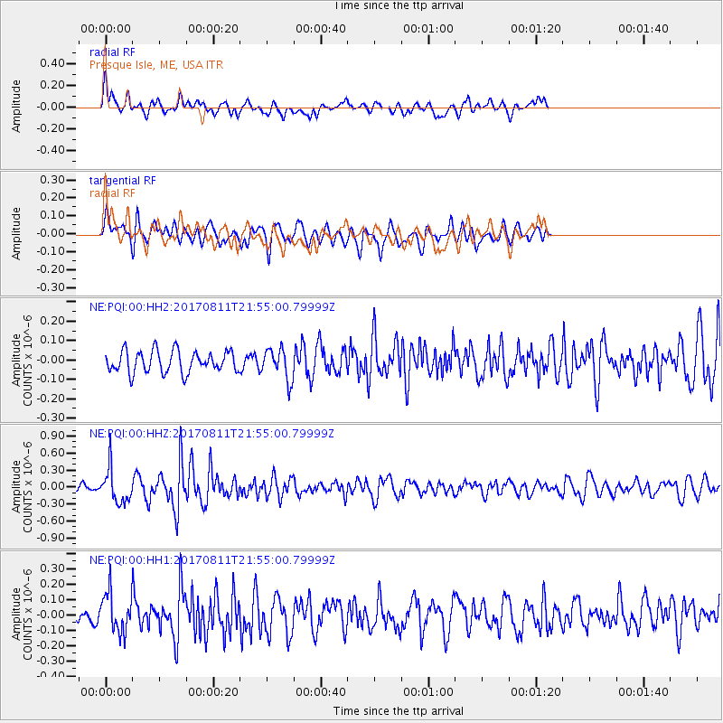
PQI Presque Isle, ME, USA - Earthquake Result Viewer
*The percent match for this event was below the threshold and hence no stack was calculated.
| Earthquake location: |
Near Coast Of Peru |
| Earthquake latitude/longitude: |
-16.3/-73.5 |
| Earthquake time(UTC): |
2017/08/11 (223) 21:45:09 GMT |
| Earthquake Depth: |
35 km |
| Earthquake Magnitude: |
5.6 Mww |
| Earthquake Catalog/Contributor: |
NEIC PDE/us |
|
| Network: |
NE New England Seismic Network |
| Station: |
PQI Presque Isle, ME, USA |
| Lat/Lon: |
46.67 N/68.02 W |
| Elevation: |
162 m |
|
| Distance: |
62.9 deg |
| Az: |
4.222 deg |
| Baz: |
185.893 deg |
| Ray Param: |
$rayparam |
*The percent match for this event was below the threshold and hence was not used in the summary stack. |
|
| Radial Match: |
61.078144 % |
| Radial Bump: |
400 |
| Transverse Match: |
59.06723 % |
| Transverse Bump: |
400 |
| SOD ConfigId: |
2140511 |
| Insert Time: |
2017-08-25 13:40:08.900 +0000 |
| GWidth: |
2.5 |
| Max Bumps: |
400 |
| Tol: |
0.001 |
|
Signal To Noise
| Channel | StoN | STA | LTA |
| NE:PQI:00:HHZ:20170811T21:55:00.79999Z | 3.590468 | 3.015729E-7 | 8.399264E-8 |
| NE:PQI:00:HH1:20170811T21:55:00.79999Z | 2.6733658 | 1.2727611E-7 | 4.7608935E-8 |
| NE:PQI:00:HH2:20170811T21:55:00.79999Z | 1.4418554 | 7.976005E-8 | 5.5317646E-8 |
| Arrivals |
| Ps | |
| PpPs | |
| PsPs/PpSs | |


