You are here: Home > Network List > TA - USArray Transportable Network (new EarthScope stations) Stations List
> Station E29M Blow River, YT, CAN > Earthquake Result Viewer
E29M Blow River, YT, CAN - Earthquake Result Viewer
| Earthquake location: |
Near East Coast Of Honshu, Japan |
| Earthquake latitude/longitude: |
38.8/142.2 |
| Earthquake time(UTC): |
2020/09/12 (256) 02:44:10 GMT |
| Earthquake Depth: |
32 km |
| Earthquake Magnitude: |
6.1 mww |
| Earthquake Catalog/Contributor: |
NEIC PDE/us |
|
| Network: |
TA USArray Transportable Network (new EarthScope stations) |
| Station: |
E29M Blow River, YT, CAN |
| Lat/Lon: |
68.39 N/137.90 W |
| Elevation: |
324 m |
|
| Distance: |
50.9 deg |
| Az: |
28.01 deg |
| Baz: |
277.628 deg |
| Ray Param: |
0.06767747 |
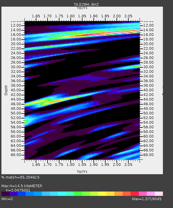
| Estimated Moho Depth: |
14.5 km |
| Estimated Crust Vp/Vs: |
2.05 |
| Assumed Crust Vp: |
5.981 km/s |
| Estimated Crust Vs: |
2.921 km/s |
| Estimated Crust Poisson's Ratio: |
0.34 |
|
| Radial Match: |
85.284615 % |
| Radial Bump: |
400 |
| Transverse Match: |
86.01393 % |
| Transverse Bump: |
400 |
| SOD ConfigId: |
22732711 |
| Insert Time: |
2020-09-26 03:21:18.060 +0000 |
| GWidth: |
2.5 |
| Max Bumps: |
400 |
| Tol: |
0.001 |
|

Signal To Noise
| Channel | StoN | STA | LTA |
| TA:E29M: :BHZ:20200912T02:52:38.625006Z | 8.231219 | 1.0853464E-6 | 1.3185732E-7 |
| TA:E29M: :BHN:20200912T02:52:38.625006Z | 1.635334 | 1.3057219E-7 | 7.9844355E-8 |
| TA:E29M: :BHE:20200912T02:52:38.625006Z | 3.075305 | 3.9197818E-7 | 1.2745994E-7 |
| Arrivals |
| Ps | 2.6 SECOND |
| PpPs | 7.1 SECOND |
| PsPs/PpSs | 9.7 SECOND |


