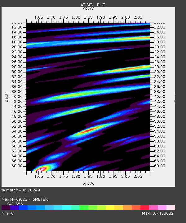
SIT Sitka, Alaska - Earthquake Result Viewer

Earthquake location: Southwestern Ryukyu Isl., Japan
Earthquake latitude/longitude: 24.2/125.1
Earthquake time(UTC): 2009/08/05 (217) 00:17:58 GMT
Earthquake Depth: 25 km
Earthquake Magnitude: 5.9 MB, 5.9 MS, 6.2 MW, 6.1 MW
Earthquake Catalog/Contributor: WHDF/NEIC
Network: AT Alaska Tsunami Warning Seismic System
Station: SIT Sitka, Alaska
Lat/Lon: 57.06 N/135.32 W
Elevation: 19 m
Distance: 75.0 deg
Az: 33.901 deg
Baz: 291.261 deg
Ray Param: 0.05192844
Estimated Moho Depth: 69.25 km
Estimated Crust Vp/Vs: 1.65
Assumed Crust Vp: 6.472 km/s
Estimated Crust Vs: 3.91 km/s
Estimated Crust Poisson's Ratio: 0.21
Radial Match: 86.70249 %
Radial Bump: 400
Transverse Match: 78.53664 %
Transverse Bump: 400
SOD ConfigId: 2622
Insert Time: 2010-03-09 01:11:32.141 +0000
GWidth: 2.5
Max Bumps: 400
Tol: 0.001

Signal To Noise

ChannelStoNSTALTA
AT:SIT: :BHZ:20090805T00:29:06.799004Z6.31967166.96775E-71.1025494E-7
AT:SIT: :BHN:20090805T00:29:06.799004Z2.0622981.6672533E-78.084444E-8
AT:SIT: :BHE:20090805T00:29:06.799004Z2.5443862.4647534E-79.687027E-8
Arrivals
Ps7.3 SECOND
PpPs27 SECOND
PsPs/PpSs35 SECOND