You are here: Home > Network List > TA - USArray Transportable Network (new EarthScope stations) Stations List
> Station H17K Granite Mountain, AK, USA > Earthquake Result Viewer
H17K Granite Mountain, AK, USA - Earthquake Result Viewer
| Earthquake location: |
Near East Coast Of Honshu, Japan |
| Earthquake latitude/longitude: |
38.8/142.2 |
| Earthquake time(UTC): |
2020/09/12 (256) 02:44:10 GMT |
| Earthquake Depth: |
32 km |
| Earthquake Magnitude: |
6.1 mww |
| Earthquake Catalog/Contributor: |
NEIC PDE/us |
|
| Network: |
TA USArray Transportable Network (new EarthScope stations) |
| Station: |
H17K Granite Mountain, AK, USA |
| Lat/Lon: |
64.94 N/159.91 W |
| Elevation: |
396 m |
|
| Distance: |
42.2 deg |
| Az: |
32.501 deg |
| Baz: |
260.485 deg |
| Ray Param: |
0.073290795 |
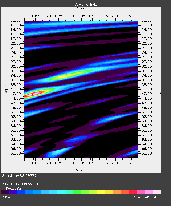
| Estimated Moho Depth: |
42.0 km |
| Estimated Crust Vp/Vs: |
1.63 |
| Assumed Crust Vp: |
6.1 km/s |
| Estimated Crust Vs: |
3.731 km/s |
| Estimated Crust Poisson's Ratio: |
0.20 |
|
| Radial Match: |
88.29377 % |
| Radial Bump: |
400 |
| Transverse Match: |
77.416115 % |
| Transverse Bump: |
400 |
| SOD ConfigId: |
22732711 |
| Insert Time: |
2020-09-26 03:21:59.792 +0000 |
| GWidth: |
2.5 |
| Max Bumps: |
400 |
| Tol: |
0.001 |
|

Signal To Noise
| Channel | StoN | STA | LTA |
| TA:H17K: :BHZ:20200912T02:51:29.900Z | 11.126271 | 7.2778306E-7 | 6.541123E-8 |
| TA:H17K: :BHN:20200912T02:51:29.900Z | 1.6019366 | 8.852796E-8 | 5.5263087E-8 |
| TA:H17K: :BHE:20200912T02:51:29.900Z | 5.0996437 | 3.3431795E-7 | 6.555712E-8 |
| Arrivals |
| Ps | 4.7 SECOND |
| PpPs | 17 SECOND |
| PsPs/PpSs | 22 SECOND |


