You are here: Home > Network List > AT - Alaska Tsunami Warning Seismic System Stations List
> Station SIT Sitka, Alaska > Earthquake Result Viewer
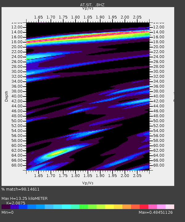
SIT Sitka, Alaska - Earthquake Result Viewer
| Earthquake location: |
Tonga Islands Region |
| Earthquake latitude/longitude: |
-23.0/-174.7 |
| Earthquake time(UTC): |
2009/03/19 (078) 18:17:40 GMT |
| Earthquake Depth: |
34 km |
| Earthquake Magnitude: |
7.0 MB, 7.6 MS, 7.6 MW, 7.6 MW |
| Earthquake Catalog/Contributor: |
WHDF/NEIC |
|
| Network: |
AT Alaska Tsunami Warning Seismic System |
| Station: |
SIT Sitka, Alaska |
| Lat/Lon: |
57.06 N/135.32 W |
| Elevation: |
19 m |
|
| Distance: |
86.4 deg |
| Az: |
20.305 deg |
| Baz: |
215.805 deg |
| Ray Param: |
0.04405434 |
| Estimated Moho Depth: |
13.25 km |
| Estimated Crust Vp/Vs: |
2.09 |
| Assumed Crust Vp: |
6.472 km/s |
| Estimated Crust Vs: |
3.1 km/s |
| Estimated Crust Poisson's Ratio: |
0.35 |
|
| Radial Match: |
98.14611 % |
| Radial Bump: |
335 |
| Transverse Match: |
94.62666 % |
| Transverse Bump: |
400 |
| SOD ConfigId: |
2658 |
| Insert Time: |
2010-03-09 01:11:48.107 +0000 |
| GWidth: |
2.5 |
| Max Bumps: |
400 |
| Tol: |
0.001 |
|

Signal To Noise
| Channel | StoN | STA | LTA |
| AT:SIT: :BHZ:20090319T18:29:48.449001Z | 11.571557 | 6.100247E-6 | 5.271759E-7 |
| AT:SIT: :BHN:20090319T18:29:48.449001Z | 3.8784475 | 1.1550577E-6 | 2.9781444E-7 |
| AT:SIT: :BHE:20090319T18:29:48.449001Z | 6.79859 | 2.271774E-6 | 3.341537E-7 |
| Arrivals |
| Ps | 2.3 SECOND |
| PpPs | 6.2 SECOND |
| PsPs/PpSs | 8.5 SECOND |


