You are here: Home > Network List > AT - Alaska Tsunami Warning Seismic System Stations List
> Station SIT Sitka, Alaska > Earthquake Result Viewer
SIT Sitka, Alaska - Earthquake Result Viewer
| Earthquake location: |
Taiwan Region |
| Earthquake latitude/longitude: |
24.1/122.2 |
| Earthquake time(UTC): |
2009/07/13 (194) 18:05:01 GMT |
| Earthquake Depth: |
17 km |
| Earthquake Magnitude: |
6.1 MB, 6.3 MS, 6.3 MW, 6.2 MW |
| Earthquake Catalog/Contributor: |
WHDF/NEIC |
|
| Network: |
AT Alaska Tsunami Warning Seismic System |
| Station: |
SIT Sitka, Alaska |
| Lat/Lon: |
57.06 N/135.32 W |
| Elevation: |
19 m |
|
| Distance: |
76.6 deg |
| Az: |
33.257 deg |
| Baz: |
293.433 deg |
| Ray Param: |
0.050866667 |
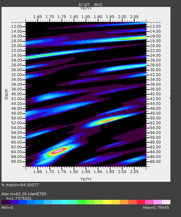
| Estimated Moho Depth: |
63.25 km |
| Estimated Crust Vp/Vs: |
1.74 |
| Assumed Crust Vp: |
6.472 km/s |
| Estimated Crust Vs: |
3.725 km/s |
| Estimated Crust Poisson's Ratio: |
0.25 |
|
| Radial Match: |
94.00077 % |
| Radial Bump: |
400 |
| Transverse Match: |
90.73728 % |
| Transverse Bump: |
400 |
| SOD ConfigId: |
2648 |
| Insert Time: |
2010-03-09 01:11:49.302 +0000 |
| GWidth: |
2.5 |
| Max Bumps: |
400 |
| Tol: |
0.001 |
|

Signal To Noise
| Channel | StoN | STA | LTA |
| AT:SIT: :BHZ:20090713T18:16:19.649004Z | 17.845396 | 1.4283819E-6 | 8.0042035E-8 |
| AT:SIT: :BHN:20090713T18:16:19.649004Z | 4.4897676 | 3.804241E-7 | 8.4731354E-8 |
| AT:SIT: :BHE:20090713T18:16:19.649004Z | 5.855057 | 5.0792926E-7 | 8.6750525E-8 |
| Arrivals |
| Ps | 7.4 SECOND |
| PpPs | 26 SECOND |
| PsPs/PpSs | 33 SECOND |


