You are here: Home > Network List > US - United States National Seismic Network Stations List
> Station HAWA Hanford, Washington, USA > Earthquake Result Viewer
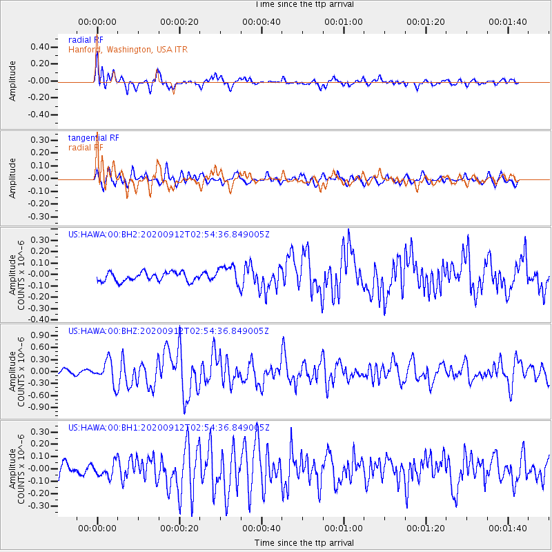
HAWA Hanford, Washington, USA - Earthquake Result Viewer
*The percent match for this event was below the threshold and hence no stack was calculated.
| Earthquake location: |
Near East Coast Of Honshu, Japan |
| Earthquake latitude/longitude: |
38.8/142.2 |
| Earthquake time(UTC): |
2020/09/12 (256) 02:44:10 GMT |
| Earthquake Depth: |
32 km |
| Earthquake Magnitude: |
6.1 mww |
| Earthquake Catalog/Contributor: |
NEIC PDE/us |
|
| Network: |
US United States National Seismic Network |
| Station: |
HAWA Hanford, Washington, USA |
| Lat/Lon: |
46.39 N/119.53 W |
| Elevation: |
364 m |
|
| Distance: |
68.1 deg |
| Az: |
47.578 deg |
| Baz: |
303.503 deg |
| Ray Param: |
$rayparam |
*The percent match for this event was below the threshold and hence was not used in the summary stack. |
|
| Radial Match: |
79.11779 % |
| Radial Bump: |
400 |
| Transverse Match: |
77.77079 % |
| Transverse Bump: |
400 |
| SOD ConfigId: |
22732711 |
| Insert Time: |
2020-09-26 03:26:01.863 +0000 |
| GWidth: |
2.5 |
| Max Bumps: |
400 |
| Tol: |
0.001 |
|
Signal To Noise
| Channel | StoN | STA | LTA |
| US:HAWA:00:BHZ:20200912T02:54:36.849005Z | 3.8184373 | 3.0040582E-7 | 7.867245E-8 |
| US:HAWA:00:BH1:20200912T02:54:36.849005Z | 0.89999104 | 5.956159E-8 | 6.61802E-8 |
| US:HAWA:00:BH2:20200912T02:54:36.849005Z | 2.1732733 | 8.4730125E-8 | 3.898733E-8 |
| Arrivals |
| Ps | |
| PpPs | |
| PsPs/PpSs | |


