You are here: Home > Network List > US - United States National Seismic Network Stations List
> Station MIAR Mount Ida, Arkansas, USA > Earthquake Result Viewer
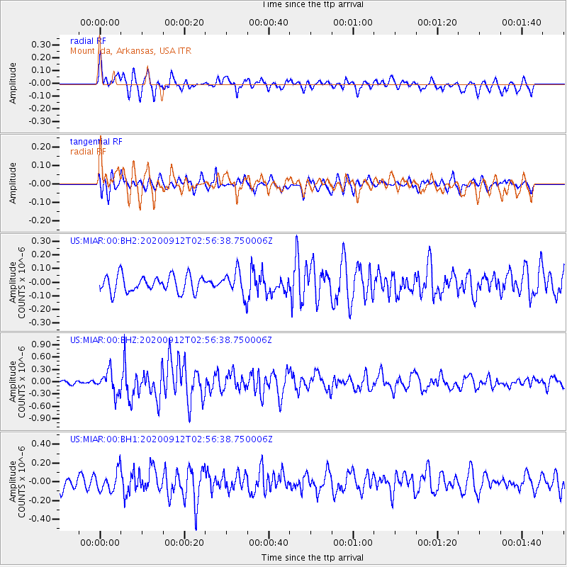
MIAR Mount Ida, Arkansas, USA - Earthquake Result Viewer
*The percent match for this event was below the threshold and hence no stack was calculated.
| Earthquake location: |
Near East Coast Of Honshu, Japan |
| Earthquake latitude/longitude: |
38.8/142.2 |
| Earthquake time(UTC): |
2020/09/12 (256) 02:44:10 GMT |
| Earthquake Depth: |
32 km |
| Earthquake Magnitude: |
6.1 mww |
| Earthquake Catalog/Contributor: |
NEIC PDE/us |
|
| Network: |
US United States National Seismic Network |
| Station: |
MIAR Mount Ida, Arkansas, USA |
| Lat/Lon: |
34.55 N/93.58 W |
| Elevation: |
207 m |
|
| Distance: |
90.6 deg |
| Az: |
43.074 deg |
| Baz: |
319.695 deg |
| Ray Param: |
$rayparam |
*The percent match for this event was below the threshold and hence was not used in the summary stack. |
|
| Radial Match: |
67.994644 % |
| Radial Bump: |
400 |
| Transverse Match: |
63.987293 % |
| Transverse Bump: |
400 |
| SOD ConfigId: |
22732711 |
| Insert Time: |
2020-09-26 03:26:19.411 +0000 |
| GWidth: |
2.5 |
| Max Bumps: |
400 |
| Tol: |
0.001 |
|
Signal To Noise
| Channel | StoN | STA | LTA |
| US:MIAR:00:BHZ:20200912T02:56:38.750006Z | 2.92112 | 2.7675537E-7 | 9.47429E-8 |
| US:MIAR:00:BH1:20200912T02:56:38.750006Z | 1.4079248 | 1.1006688E-7 | 7.817667E-8 |
| US:MIAR:00:BH2:20200912T02:56:38.750006Z | 1.5124035 | 9.2029396E-8 | 6.0849764E-8 |
| Arrivals |
| Ps | |
| PpPs | |
| PsPs/PpSs | |


