You are here: Home > Network List > US - United States National Seismic Network Stations List
> Station WMOK Wichita Mountains, Oklahoma, USA > Earthquake Result Viewer
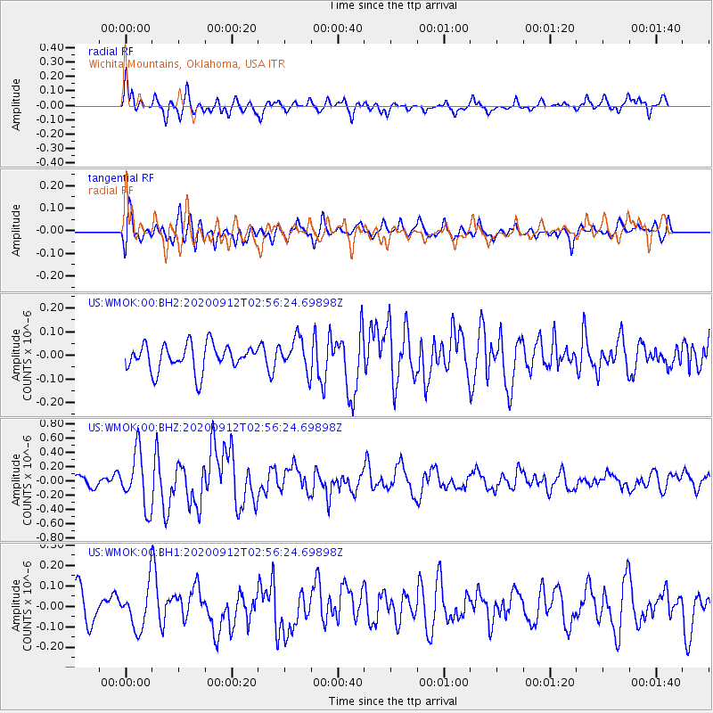
WMOK Wichita Mountains, Oklahoma, USA - Earthquake Result Viewer
*The percent match for this event was below the threshold and hence no stack was calculated.
| Earthquake location: |
Near East Coast Of Honshu, Japan |
| Earthquake latitude/longitude: |
38.8/142.2 |
| Earthquake time(UTC): |
2020/09/12 (256) 02:44:10 GMT |
| Earthquake Depth: |
32 km |
| Earthquake Magnitude: |
6.1 mww |
| Earthquake Catalog/Contributor: |
NEIC PDE/us |
|
| Network: |
US United States National Seismic Network |
| Station: |
WMOK Wichita Mountains, Oklahoma, USA |
| Lat/Lon: |
34.74 N/98.78 W |
| Elevation: |
486 m |
|
| Distance: |
87.6 deg |
| Az: |
46.147 deg |
| Baz: |
316.797 deg |
| Ray Param: |
$rayparam |
*The percent match for this event was below the threshold and hence was not used in the summary stack. |
|
| Radial Match: |
65.582596 % |
| Radial Bump: |
400 |
| Transverse Match: |
64.908424 % |
| Transverse Bump: |
400 |
| SOD ConfigId: |
22732711 |
| Insert Time: |
2020-09-26 03:26:35.343 +0000 |
| GWidth: |
2.5 |
| Max Bumps: |
400 |
| Tol: |
0.001 |
|
Signal To Noise
| Channel | StoN | STA | LTA |
| US:WMOK:00:BHZ:20200912T02:56:24.69898Z | 6.1676984 | 3.9302193E-7 | 6.372263E-8 |
| US:WMOK:00:BH1:20200912T02:56:24.69898Z | 1.3939514 | 1.0608316E-7 | 7.610248E-8 |
| US:WMOK:00:BH2:20200912T02:56:24.69898Z | 1.2572294 | 7.019772E-8 | 5.5835248E-8 |
| Arrivals |
| Ps | |
| PpPs | |
| PsPs/PpSs | |


