You are here: Home > Network List > UW - Pacific Northwest Regional Seismic Network Stations List
> Station WA2 Wahluke Slope previous ISC code: WAH2 > Earthquake Result Viewer
WA2 Wahluke Slope previous ISC code: WAH2 - Earthquake Result Viewer
| Earthquake location: |
Near East Coast Of Honshu, Japan |
| Earthquake latitude/longitude: |
38.8/142.2 |
| Earthquake time(UTC): |
2020/09/12 (256) 02:44:10 GMT |
| Earthquake Depth: |
32 km |
| Earthquake Magnitude: |
6.1 mww |
| Earthquake Catalog/Contributor: |
NEIC PDE/us |
|
| Network: |
UW Pacific Northwest Regional Seismic Network |
| Station: |
WA2 Wahluke Slope previous ISC code: WAH2 |
| Lat/Lon: |
46.76 N/119.57 W |
| Elevation: |
244 m |
|
| Distance: |
67.9 deg |
| Az: |
47.266 deg |
| Baz: |
303.361 deg |
| Ray Param: |
0.05661001 |
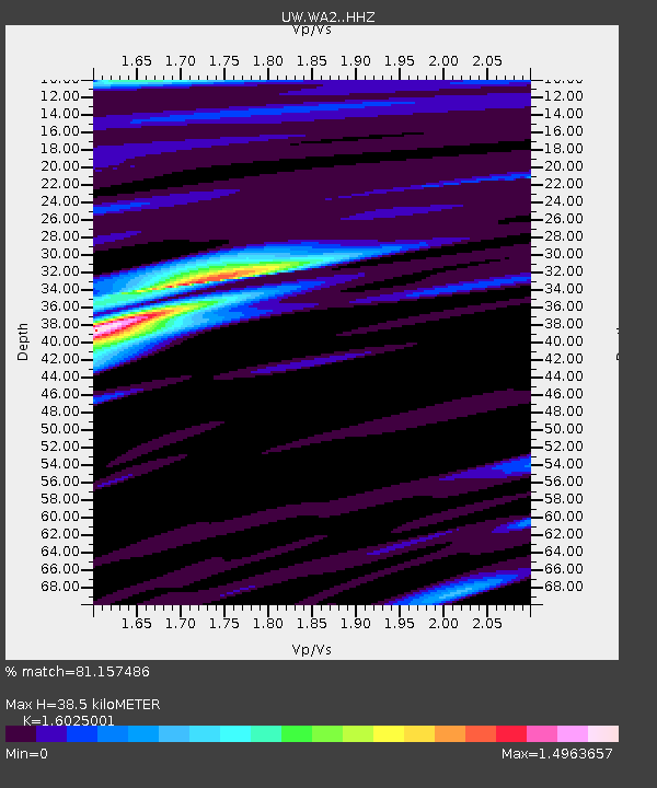
| Estimated Moho Depth: |
38.5 km |
| Estimated Crust Vp/Vs: |
1.60 |
| Assumed Crust Vp: |
6.419 km/s |
| Estimated Crust Vs: |
4.006 km/s |
| Estimated Crust Poisson's Ratio: |
0.18 |
|
| Radial Match: |
81.157486 % |
| Radial Bump: |
400 |
| Transverse Match: |
59.450874 % |
| Transverse Bump: |
400 |
| SOD ConfigId: |
22732711 |
| Insert Time: |
2020-09-26 03:28:34.032 +0000 |
| GWidth: |
2.5 |
| Max Bumps: |
400 |
| Tol: |
0.001 |
|

Signal To Noise
| Channel | StoN | STA | LTA |
| UW:WA2: :HHZ:20200912T02:54:35.460028Z | 3.43612 | 3.4408046E-7 | 1.0013633E-7 |
| UW:WA2: :HHN:20200912T02:54:35.460028Z | 0.86993784 | 6.4922325E-8 | 7.4628694E-8 |
| UW:WA2: :HHE:20200912T02:54:35.460028Z | 0.7675135 | 6.248808E-8 | 8.141626E-8 |
| Arrivals |
| Ps | 3.8 SECOND |
| PpPs | 15 SECOND |
| PsPs/PpSs | 19 SECOND |


