You are here: Home > Network List > WY - Yellowstone Wyoming Seismic Network Stations List
> Station YHH Holmes Hill, YNP, WY, USA > Earthquake Result Viewer
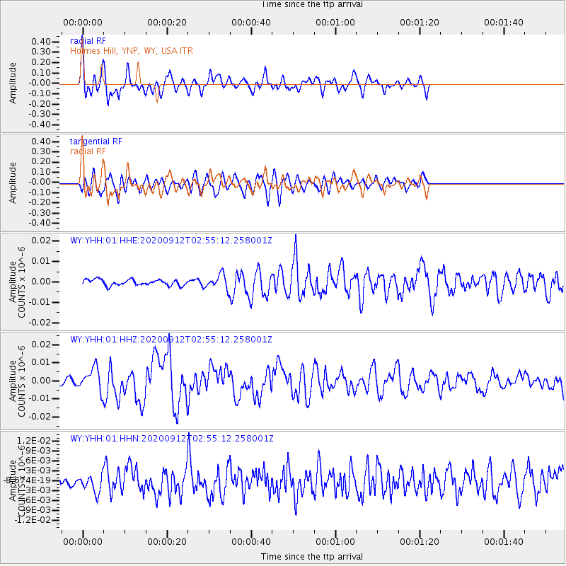
YHH Holmes Hill, YNP, WY, USA - Earthquake Result Viewer
*The percent match for this event was below the threshold and hence no stack was calculated.
| Earthquake location: |
Near East Coast Of Honshu, Japan |
| Earthquake latitude/longitude: |
38.8/142.2 |
| Earthquake time(UTC): |
2020/09/12 (256) 02:44:10 GMT |
| Earthquake Depth: |
32 km |
| Earthquake Magnitude: |
6.1 mww |
| Earthquake Catalog/Contributor: |
NEIC PDE/us |
|
| Network: |
WY Yellowstone Wyoming Seismic Network |
| Station: |
YHH Holmes Hill, YNP, WY, USA |
| Lat/Lon: |
44.79 N/110.85 W |
| Elevation: |
2717 m |
|
| Distance: |
74.0 deg |
| Az: |
45.14 deg |
| Baz: |
308.898 deg |
| Ray Param: |
$rayparam |
*The percent match for this event was below the threshold and hence was not used in the summary stack. |
|
| Radial Match: |
62.897358 % |
| Radial Bump: |
400 |
| Transverse Match: |
61.67271 % |
| Transverse Bump: |
400 |
| SOD ConfigId: |
22732711 |
| Insert Time: |
2020-09-26 03:29:20.102 +0000 |
| GWidth: |
2.5 |
| Max Bumps: |
400 |
| Tol: |
0.001 |
|
Signal To Noise
| Channel | StoN | STA | LTA |
| WY:YHH:01:HHZ:20200912T02:55:12.258001Z | 3.4151275 | 6.4633223E-9 | 1.8925568E-9 |
| WY:YHH:01:HHN:20200912T02:55:12.258001Z | 1.4287935 | 2.6533322E-9 | 1.8570439E-9 |
| WY:YHH:01:HHE:20200912T02:55:12.258001Z | 2.5255609 | 3.517879E-9 | 1.3929101E-9 |
| Arrivals |
| Ps | |
| PpPs | |
| PsPs/PpSs | |


