You are here: Home > Network List > US - United States National Seismic Network Stations List
> Station MSO Missoula, Montana, USA > Earthquake Result Viewer
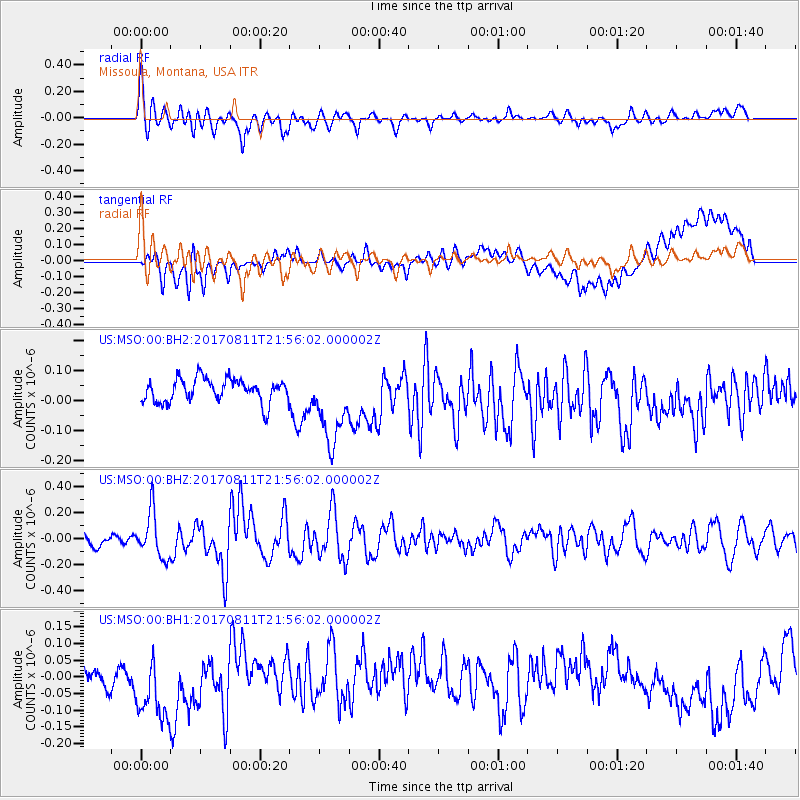
MSO Missoula, Montana, USA - Earthquake Result Viewer
*The percent match for this event was below the threshold and hence no stack was calculated.
| Earthquake location: |
Near Coast Of Peru |
| Earthquake latitude/longitude: |
-16.3/-73.5 |
| Earthquake time(UTC): |
2017/08/11 (223) 21:45:09 GMT |
| Earthquake Depth: |
35 km |
| Earthquake Magnitude: |
5.6 Mww |
| Earthquake Catalog/Contributor: |
NEIC PDE/us |
|
| Network: |
US United States National Seismic Network |
| Station: |
MSO Missoula, Montana, USA |
| Lat/Lon: |
46.83 N/113.94 W |
| Elevation: |
1264 m |
|
| Distance: |
72.6 deg |
| Az: |
332.167 deg |
| Baz: |
139.231 deg |
| Ray Param: |
$rayparam |
*The percent match for this event was below the threshold and hence was not used in the summary stack. |
|
| Radial Match: |
70.816124 % |
| Radial Bump: |
400 |
| Transverse Match: |
36.755043 % |
| Transverse Bump: |
400 |
| SOD ConfigId: |
2140511 |
| Insert Time: |
2017-08-25 13:42:08.417 +0000 |
| GWidth: |
2.5 |
| Max Bumps: |
400 |
| Tol: |
0.001 |
|
Signal To Noise
| Channel | StoN | STA | LTA |
| US:MSO:00:BHZ:20170811T21:56:02.000002Z | 2.8778079 | 1.7311935E-7 | 6.015667E-8 |
| US:MSO:00:BH1:20170811T21:56:02.000002Z | 2.8687801 | 1.2347721E-7 | 4.3041712E-8 |
| US:MSO:00:BH2:20170811T21:56:02.000002Z | 3.3143303 | 1.2981633E-7 | 3.9168192E-8 |
| Arrivals |
| Ps | |
| PpPs | |
| PsPs/PpSs | |


