You are here: Home > Network List > TA - USArray Transportable Network (new EarthScope stations) Stations List
> Station F21K Alatna River, AK, USA > Earthquake Result Viewer
F21K Alatna River, AK, USA - Earthquake Result Viewer
| Earthquake location: |
Vanuatu Islands |
| Earthquake latitude/longitude: |
-17.3/167.7 |
| Earthquake time(UTC): |
2020/09/12 (256) 08:34:27 GMT |
| Earthquake Depth: |
10 km |
| Earthquake Magnitude: |
5.9 mww |
| Earthquake Catalog/Contributor: |
NEIC PDE/us |
|
| Network: |
TA USArray Transportable Network (new EarthScope stations) |
| Station: |
F21K Alatna River, AK, USA |
| Lat/Lon: |
67.22 N/153.48 W |
| Elevation: |
597 m |
|
| Distance: |
89.0 deg |
| Az: |
14.131 deg |
| Baz: |
216.809 deg |
| Ray Param: |
0.042210314 |
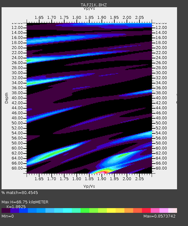
| Estimated Moho Depth: |
69.75 km |
| Estimated Crust Vp/Vs: |
1.89 |
| Assumed Crust Vp: |
6.455 km/s |
| Estimated Crust Vs: |
3.411 km/s |
| Estimated Crust Poisson's Ratio: |
0.31 |
|
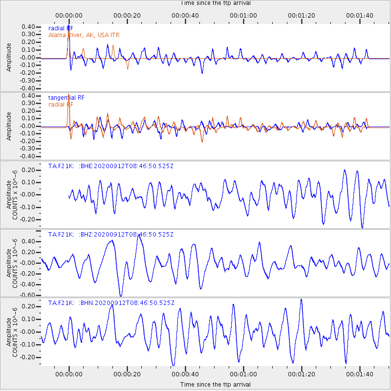
| Radial Match: |
80.4545 % |
| Radial Bump: |
400 |
| Transverse Match: |
72.482765 % |
| Transverse Bump: |
400 |
| SOD ConfigId: |
22732711 |
| Insert Time: |
2020-09-26 08:46:48.067 +0000 |
| GWidth: |
2.5 |
| Max Bumps: |
400 |
| Tol: |
0.001 |
|
Signal To Noise
| Channel | StoN | STA | LTA |
| TA:F21K: :BHZ:20200912T08:46:50.525Z | 2.294282 | 1.3995475E-7 | 6.100155E-8 |
| TA:F21K: :BHN:20200912T08:46:50.525Z | 1.5573208 | 6.986571E-8 | 4.486276E-8 |
| TA:F21K: :BHE:20200912T08:46:50.525Z | 1.141719 | 6.3544014E-8 | 5.5656447E-8 |
| Arrivals |
| Ps | 9.8 SECOND |
| PpPs | 31 SECOND |
| PsPs/PpSs | 40 SECOND |


