You are here: Home > Network List > TA - USArray Transportable Network (new EarthScope stations) Stations List
> Station L15K Ungalak Mountain, AK, USA > Earthquake Result Viewer
L15K Ungalak Mountain, AK, USA - Earthquake Result Viewer
| Earthquake location: |
Vanuatu Islands |
| Earthquake latitude/longitude: |
-17.3/167.7 |
| Earthquake time(UTC): |
2020/09/12 (256) 08:34:27 GMT |
| Earthquake Depth: |
10 km |
| Earthquake Magnitude: |
5.9 mww |
| Earthquake Catalog/Contributor: |
NEIC PDE/us |
|
| Network: |
TA USArray Transportable Network (new EarthScope stations) |
| Station: |
L15K Ungalak Mountain, AK, USA |
| Lat/Lon: |
61.68 N/161.49 W |
| Elevation: |
219 m |
|
| Distance: |
82.4 deg |
| Az: |
14.27 deg |
| Baz: |
209.597 deg |
| Ray Param: |
0.046913784 |
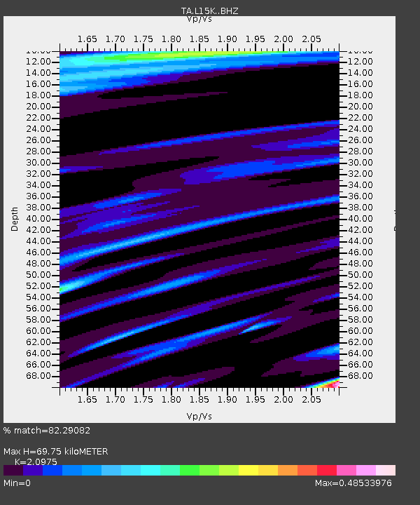
| Estimated Moho Depth: |
69.75 km |
| Estimated Crust Vp/Vs: |
2.10 |
| Assumed Crust Vp: |
6.182 km/s |
| Estimated Crust Vs: |
2.947 km/s |
| Estimated Crust Poisson's Ratio: |
0.35 |
|
| Radial Match: |
82.29082 % |
| Radial Bump: |
400 |
| Transverse Match: |
75.84174 % |
| Transverse Bump: |
400 |
| SOD ConfigId: |
22732711 |
| Insert Time: |
2020-09-26 08:47:24.363 +0000 |
| GWidth: |
2.5 |
| Max Bumps: |
400 |
| Tol: |
0.001 |
|

Signal To Noise
| Channel | StoN | STA | LTA |
| TA:L15K: :BHZ:20200912T08:46:18.124976Z | 1.9864631 | 1.6802221E-7 | 8.4583604E-8 |
| TA:L15K: :BHN:20200912T08:46:18.124976Z | 0.9426331 | 7.950621E-8 | 8.434481E-8 |
| TA:L15K: :BHE:20200912T08:46:18.124976Z | 1.0213556 | 7.0148644E-8 | 6.86819E-8 |
| Arrivals |
| Ps | 13 SECOND |
| PpPs | 34 SECOND |
| PsPs/PpSs | 47 SECOND |


