You are here: Home > Network List > TA - USArray Transportable Network (new EarthScope stations) Stations List
> Station L16K Owhat River, AK, USA > Earthquake Result Viewer
L16K Owhat River, AK, USA - Earthquake Result Viewer
| Earthquake location: |
Vanuatu Islands |
| Earthquake latitude/longitude: |
-17.3/167.7 |
| Earthquake time(UTC): |
2020/09/12 (256) 08:34:27 GMT |
| Earthquake Depth: |
10 km |
| Earthquake Magnitude: |
5.9 mww |
| Earthquake Catalog/Contributor: |
NEIC PDE/us |
|
| Network: |
TA USArray Transportable Network (new EarthScope stations) |
| Station: |
L16K Owhat River, AK, USA |
| Lat/Lon: |
61.71 N/159.47 W |
| Elevation: |
227 m |
|
| Distance: |
82.9 deg |
| Az: |
15.086 deg |
| Baz: |
211.47 deg |
| Ray Param: |
0.0465583 |
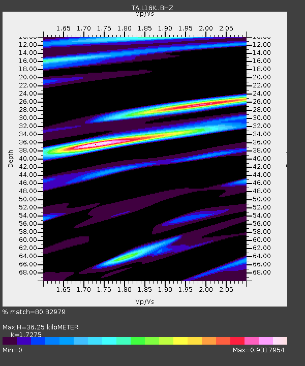
| Estimated Moho Depth: |
36.25 km |
| Estimated Crust Vp/Vs: |
1.73 |
| Assumed Crust Vp: |
6.276 km/s |
| Estimated Crust Vs: |
3.633 km/s |
| Estimated Crust Poisson's Ratio: |
0.25 |
|
| Radial Match: |
80.82979 % |
| Radial Bump: |
400 |
| Transverse Match: |
71.32851 % |
| Transverse Bump: |
400 |
| SOD ConfigId: |
22732711 |
| Insert Time: |
2020-09-26 08:47:26.261 +0000 |
| GWidth: |
2.5 |
| Max Bumps: |
400 |
| Tol: |
0.001 |
|

Signal To Noise
| Channel | StoN | STA | LTA |
| TA:L16K: :BHZ:20200912T08:46:20.800025Z | 3.7606564 | 2.5902543E-7 | 6.887772E-8 |
| TA:L16K: :BHN:20200912T08:46:20.800025Z | 1.1119611 | 9.6041035E-8 | 8.637086E-8 |
| TA:L16K: :BHE:20200912T08:46:20.800025Z | 0.8437307 | 8.782567E-8 | 1.0409207E-7 |
| Arrivals |
| Ps | 4.3 SECOND |
| PpPs | 15 SECOND |
| PsPs/PpSs | 20 SECOND |


