You are here: Home > Network List > AV - Alaska Volcano Observatory Stations List
> Station MAPS Pakushin Southeast, Makushin Volcano, Alaska > Earthquake Result Viewer
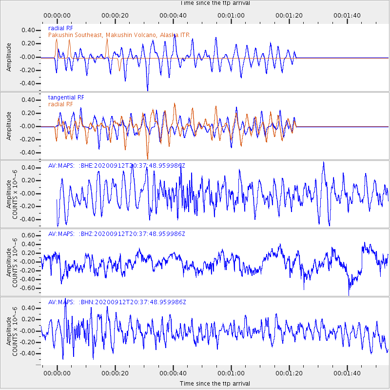
MAPS Pakushin Southeast, Makushin Volcano, Alaska - Earthquake Result Viewer
*The percent match for this event was below the threshold and hence no stack was calculated.
| Earthquake location: |
Banda Sea |
| Earthquake latitude/longitude: |
-7.3/128.5 |
| Earthquake time(UTC): |
2020/09/12 (256) 20:26:19 GMT |
| Earthquake Depth: |
141 km |
| Earthquake Magnitude: |
5.2 Mww |
| Earthquake Catalog/Contributor: |
NEIC PDE/us |
|
| Network: |
AV Alaska Volcano Observatory |
| Station: |
MAPS Pakushin Southeast, Makushin Volcano, Alaska |
| Lat/Lon: |
53.81 N/166.94 W |
| Elevation: |
333 m |
|
| Distance: |
81.3 deg |
| Az: |
32.815 deg |
| Baz: |
245.015 deg |
| Ray Param: |
$rayparam |
*The percent match for this event was below the threshold and hence was not used in the summary stack. |
|
| Radial Match: |
53.649906 % |
| Radial Bump: |
400 |
| Transverse Match: |
49.60772 % |
| Transverse Bump: |
400 |
| SOD ConfigId: |
22732711 |
| Insert Time: |
2020-09-26 20:29:37.863 +0000 |
| GWidth: |
2.5 |
| Max Bumps: |
400 |
| Tol: |
0.001 |
|
Signal To Noise
| Channel | StoN | STA | LTA |
| AV:MAPS: :BHZ:20200912T20:37:48.959986Z | 1.9036226 | 2.454238E-7 | 1.289246E-7 |
| AV:MAPS: :BHN:20200912T20:37:48.959986Z | 2.1330445 | 2.5021345E-7 | 1.17303436E-7 |
| AV:MAPS: :BHE:20200912T20:37:48.959986Z | 1.192938 | 2.4278089E-7 | 2.035151E-7 |
| Arrivals |
| Ps | |
| PpPs | |
| PsPs/PpSs | |


