You are here: Home > Network List > TA - USArray Transportable Network (new EarthScope stations) Stations List
> Station D23K Nanushuk River, AK USA > Earthquake Result Viewer
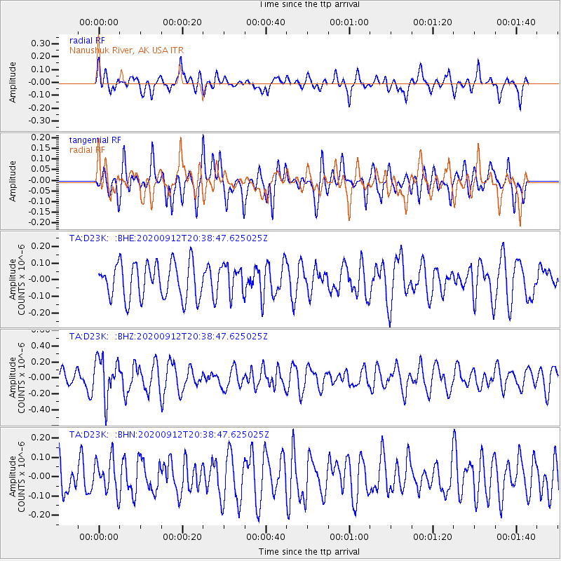
D23K Nanushuk River, AK USA - Earthquake Result Viewer
*The percent match for this event was below the threshold and hence no stack was calculated.
| Earthquake location: |
Banda Sea |
| Earthquake latitude/longitude: |
-7.3/128.5 |
| Earthquake time(UTC): |
2020/09/12 (256) 20:26:19 GMT |
| Earthquake Depth: |
141 km |
| Earthquake Magnitude: |
5.2 Mww |
| Earthquake Catalog/Contributor: |
NEIC PDE/us |
|
| Network: |
TA USArray Transportable Network (new EarthScope stations) |
| Station: |
D23K Nanushuk River, AK USA |
| Lat/Lon: |
68.97 N/150.68 W |
| Elevation: |
406 m |
|
| Distance: |
93.5 deg |
| Az: |
20.923 deg |
| Baz: |
258.876 deg |
| Ray Param: |
$rayparam |
*The percent match for this event was below the threshold and hence was not used in the summary stack. |
|
| Radial Match: |
57.59881 % |
| Radial Bump: |
400 |
| Transverse Match: |
50.284325 % |
| Transverse Bump: |
400 |
| SOD ConfigId: |
22732711 |
| Insert Time: |
2020-09-26 20:32:47.075 +0000 |
| GWidth: |
2.5 |
| Max Bumps: |
400 |
| Tol: |
0.001 |
|
Signal To Noise
| Channel | StoN | STA | LTA |
| TA:D23K: :BHZ:20200912T20:38:47.625025Z | 1.8872491 | 2.5655362E-7 | 1.3594051E-7 |
| TA:D23K: :BHN:20200912T20:38:47.625025Z | 0.96715003 | 9.219177E-8 | 9.532313E-8 |
| TA:D23K: :BHE:20200912T20:38:47.625025Z | 0.81129843 | 8.656977E-8 | 1.06705215E-7 |
| Arrivals |
| Ps | |
| PpPs | |
| PsPs/PpSs | |


