You are here: Home > Network List > G - GEOSCOPE Stations List
> Station KIP Kipapa, Hawai, U.S.A. (Pacific Ocean) > Earthquake Result Viewer
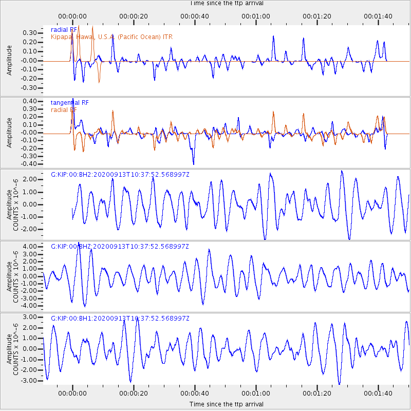
KIP Kipapa, Hawai, U.S.A. (Pacific Ocean) - Earthquake Result Viewer
*The percent match for this event was below the threshold and hence no stack was calculated.
| Earthquake location: |
Eastern New Guinea Reg., P.N.G. |
| Earthquake latitude/longitude: |
-6.0/147.0 |
| Earthquake time(UTC): |
2020/09/13 (257) 10:28:19 GMT |
| Earthquake Depth: |
56 km |
| Earthquake Magnitude: |
5.1 Mww |
| Earthquake Catalog/Contributor: |
NEIC PDE/us |
|
| Network: |
G GEOSCOPE |
| Station: |
KIP Kipapa, Hawai, U.S.A. (Pacific Ocean) |
| Lat/Lon: |
21.42 N/158.01 W |
| Elevation: |
70 m |
|
| Distance: |
60.4 deg |
| Az: |
61.334 deg |
| Baz: |
249.479 deg |
| Ray Param: |
$rayparam |
*The percent match for this event was below the threshold and hence was not used in the summary stack. |
|
| Radial Match: |
54.05119 % |
| Radial Bump: |
400 |
| Transverse Match: |
56.936325 % |
| Transverse Bump: |
400 |
| SOD ConfigId: |
22732711 |
| Insert Time: |
2020-09-27 10:35:14.305 +0000 |
| GWidth: |
2.5 |
| Max Bumps: |
400 |
| Tol: |
0.001 |
|
Signal To Noise
| Channel | StoN | STA | LTA |
| G:KIP:00:BHZ:20200913T10:37:52.568997Z | 2.60744 | 2.8367317E-6 | 1.0879374E-6 |
| G:KIP:00:BH1:20200913T10:37:52.568997Z | 0.59199804 | 7.437911E-7 | 1.2564079E-6 |
| G:KIP:00:BH2:20200913T10:37:52.568997Z | 0.8986595 | 9.013959E-7 | 1.003045E-6 |
| Arrivals |
| Ps | |
| PpPs | |
| PsPs/PpSs | |


