You are here: Home > Network List > AT - Alaska Tsunami Warning Seismic System Stations List
> Station SMY Shemya, Alaska > Earthquake Result Viewer
SMY Shemya, Alaska - Earthquake Result Viewer
| Earthquake location: |
Samoa Islands Region |
| Earthquake latitude/longitude: |
-15.5/-172.1 |
| Earthquake time(UTC): |
2009/09/29 (272) 17:48:10 GMT |
| Earthquake Depth: |
18 km |
| Earthquake Magnitude: |
7.1 MB, 8.1 MS, 8.1 MW, 8.0 MW |
| Earthquake Catalog/Contributor: |
WHDF/NEIC |
|
| Network: |
AT Alaska Tsunami Warning Seismic System |
| Station: |
SMY Shemya, Alaska |
| Lat/Lon: |
52.73 N/174.10 E |
| Elevation: |
58 m |
|
| Distance: |
69.0 deg |
| Az: |
351.059 deg |
| Baz: |
165.735 deg |
| Ray Param: |
0.05593415 |
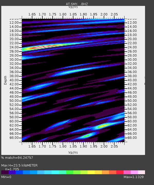
| Estimated Moho Depth: |
23.5 km |
| Estimated Crust Vp/Vs: |
1.71 |
| Assumed Crust Vp: |
3.999 km/s |
| Estimated Crust Vs: |
2.345 km/s |
| Estimated Crust Poisson's Ratio: |
0.24 |
|
| Radial Match: |
94.24757 % |
| Radial Bump: |
384 |
| Transverse Match: |
80.460686 % |
| Transverse Bump: |
400 |
| SOD ConfigId: |
2622 |
| Insert Time: |
2010-03-09 01:14:47.828 +0000 |
| GWidth: |
2.5 |
| Max Bumps: |
400 |
| Tol: |
0.001 |
|

Signal To Noise
| Channel | StoN | STA | LTA |
| AT:SMY: :BHZ:20090929T17:58:43.898997Z | 1.6661525 | 3.870373E-6 | 2.3229404E-6 |
| AT:SMY: :BHN:20090929T17:58:43.898997Z | 1.1172793 | 1.9549848E-6 | 1.7497727E-6 |
| AT:SMY: :BHE:20090929T17:58:43.898997Z | 1.4073757 | 5.2947453E-6 | 3.7621408E-6 |
| Arrivals |
| Ps | 4.2 SECOND |
| PpPs | 16 SECOND |
| PsPs/PpSs | 20 SECOND |


