You are here: Home > Network List > AT - Alaska Tsunami Warning Seismic System Stations List
> Station SMY Shemya, Alaska > Earthquake Result Viewer
SMY Shemya, Alaska - Earthquake Result Viewer
| Earthquake location: |
Mindanao, Philippines |
| Earthquake latitude/longitude: |
5.4/126.4 |
| Earthquake time(UTC): |
2009/06/14 (165) 05:58:43 GMT |
| Earthquake Depth: |
35 km |
| Earthquake Magnitude: |
5.7 MB, 5.7 MS, 6.1 MW, 6.1 MW |
| Earthquake Catalog/Contributor: |
WHDF/NEIC |
|
| Network: |
AT Alaska Tsunami Warning Seismic System |
| Station: |
SMY Shemya, Alaska |
| Lat/Lon: |
52.73 N/174.10 E |
| Elevation: |
58 m |
|
| Distance: |
61.2 deg |
| Az: |
30.858 deg |
| Baz: |
237.116 deg |
| Ray Param: |
0.060954686 |
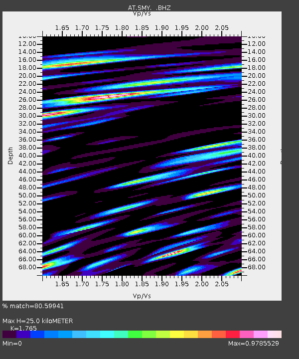
| Estimated Moho Depth: |
25.0 km |
| Estimated Crust Vp/Vs: |
1.76 |
| Assumed Crust Vp: |
3.999 km/s |
| Estimated Crust Vs: |
2.265 km/s |
| Estimated Crust Poisson's Ratio: |
0.26 |
|
| Radial Match: |
80.59941 % |
| Radial Bump: |
400 |
| Transverse Match: |
65.30012 % |
| Transverse Bump: |
400 |
| SOD ConfigId: |
2648 |
| Insert Time: |
2010-03-09 01:14:51.198 +0000 |
| GWidth: |
2.5 |
| Max Bumps: |
400 |
| Tol: |
0.001 |
|

Signal To Noise
| Channel | StoN | STA | LTA |
| AT:SMY: :BHZ:20090614T06:08:23.949016Z | 8.40847 | 1.4231695E-6 | 1.6925428E-7 |
| AT:SMY: :BHN:20090614T06:08:23.949016Z | 1.8994465 | 4.6610444E-7 | 2.453896E-7 |
| AT:SMY: :BHE:20090614T06:08:23.949016Z | 1.740546 | 4.7117084E-7 | 2.7070288E-7 |
| Arrivals |
| Ps | 4.9 SECOND |
| PpPs | 17 SECOND |
| PsPs/PpSs | 22 SECOND |


