You are here: Home > Network List > 4T - Texas Seismological Network (TexNet Stations) Stations List
> Station NM01 Eunice > Earthquake Result Viewer
NM01 Eunice - Earthquake Result Viewer
| Earthquake location: |
Kamchatka Peninsula, Russia |
| Earthquake latitude/longitude: |
55.9/158.5 |
| Earthquake time(UTC): |
2020/09/15 (259) 03:41:28 GMT |
| Earthquake Depth: |
344 km |
| Earthquake Magnitude: |
6.4 Mww |
| Earthquake Catalog/Contributor: |
NEIC PDE/us |
|
| Network: |
4T Texas Seismological Network (TexNet Stations) |
| Station: |
NM01 Eunice |
| Lat/Lon: |
32.36 N/103.40 W |
| Elevation: |
1051 m |
|
| Distance: |
68.1 deg |
| Az: |
64.539 deg |
| Baz: |
323.1 deg |
| Ray Param: |
0.055442642 |
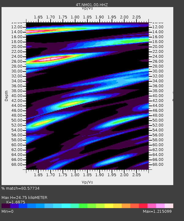
| Estimated Moho Depth: |
24.75 km |
| Estimated Crust Vp/Vs: |
1.70 |
| Assumed Crust Vp: |
6.129 km/s |
| Estimated Crust Vs: |
3.611 km/s |
| Estimated Crust Poisson's Ratio: |
0.23 |
|
| Radial Match: |
80.57734 % |
| Radial Bump: |
400 |
| Transverse Match: |
61.35188 % |
| Transverse Bump: |
400 |
| SOD ConfigId: |
22732711 |
| Insert Time: |
2020-09-29 03:42:31.156 +0000 |
| GWidth: |
2.5 |
| Max Bumps: |
400 |
| Tol: |
0.001 |
|

Signal To Noise
| Channel | StoN | STA | LTA |
| 4T:NM01:00:HHZ:20200915T03:51:20.764991Z | 14.770113 | 1.699633E-6 | 1.15072446E-7 |
| 4T:NM01:00:HH1:20200915T03:51:20.764991Z | 3.8292115 | 5.1724743E-7 | 1.3507936E-7 |
| 4T:NM01:00:HH2:20200915T03:51:20.764991Z | 3.0343885 | 4.229131E-7 | 1.3937341E-7 |
| Arrivals |
| Ps | 2.9 SECOND |
| PpPs | 11 SECOND |
| PsPs/PpSs | 13 SECOND |


