You are here: Home > Network List > CC - Cascade Chain Volcano Monitoring Stations List
> Station SWF2 Southwest Flank moved down hill, Mt. St. Helens, WA > Earthquake Result Viewer
SWF2 Southwest Flank moved down hill, Mt. St. Helens, WA - Earthquake Result Viewer
| Earthquake location: |
Kamchatka Peninsula, Russia |
| Earthquake latitude/longitude: |
55.9/158.5 |
| Earthquake time(UTC): |
2020/09/15 (259) 03:41:28 GMT |
| Earthquake Depth: |
344 km |
| Earthquake Magnitude: |
6.4 Mww |
| Earthquake Catalog/Contributor: |
NEIC PDE/us |
|
| Network: |
CC Cascade Chain Volcano Monitoring |
| Station: |
SWF2 Southwest Flank moved down hill, Mt. St. Helens, WA |
| Lat/Lon: |
46.18 N/122.22 W |
| Elevation: |
1548 m |
|
| Distance: |
48.2 deg |
| Az: |
66.392 deg |
| Baz: |
312.078 deg |
| Ray Param: |
0.06812128 |
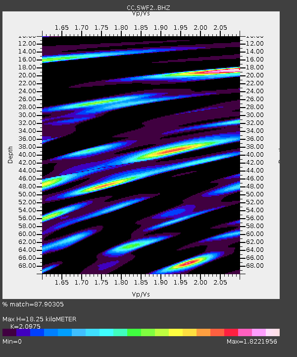
| Estimated Moho Depth: |
18.25 km |
| Estimated Crust Vp/Vs: |
2.10 |
| Assumed Crust Vp: |
6.566 km/s |
| Estimated Crust Vs: |
3.13 km/s |
| Estimated Crust Poisson's Ratio: |
0.35 |
|
| Radial Match: |
87.90305 % |
| Radial Bump: |
400 |
| Transverse Match: |
80.26554 % |
| Transverse Bump: |
400 |
| SOD ConfigId: |
22732711 |
| Insert Time: |
2020-09-29 03:46:39.862 +0000 |
| GWidth: |
2.5 |
| Max Bumps: |
400 |
| Tol: |
0.001 |
|

Signal To Noise
| Channel | StoN | STA | LTA |
| CC:SWF2: :BHZ:20200915T03:49:04.179999Z | 38.871773 | 3.221205E-6 | 8.286745E-8 |
| CC:SWF2: :BHN:20200915T03:49:04.179999Z | 6.2855315 | 1.4533468E-6 | 2.31221E-7 |
| CC:SWF2: :BHE:20200915T03:49:04.179999Z | 7.3632183 | 1.6419069E-6 | 2.2298767E-7 |
| Arrivals |
| Ps | 3.2 SECOND |
| PpPs | 8.2 SECOND |
| PsPs/PpSs | 11 SECOND |


