You are here: Home > Network List > CI - Caltech Regional Seismic Network Stations List
> Station LRL Laurel Mtn Radio Fac, Ridgecrest, CA, USA > Earthquake Result Viewer
LRL Laurel Mtn Radio Fac, Ridgecrest, CA, USA - Earthquake Result Viewer
| Earthquake location: |
Kamchatka Peninsula, Russia |
| Earthquake latitude/longitude: |
55.9/158.5 |
| Earthquake time(UTC): |
2020/09/15 (259) 03:41:28 GMT |
| Earthquake Depth: |
344 km |
| Earthquake Magnitude: |
6.4 Mww |
| Earthquake Catalog/Contributor: |
NEIC PDE/us |
|
| Network: |
CI Caltech Regional Seismic Network |
| Station: |
LRL Laurel Mtn Radio Fac, Ridgecrest, CA, USA |
| Lat/Lon: |
35.48 N/117.68 W |
| Elevation: |
1340 m |
|
| Distance: |
58.2 deg |
| Az: |
72.677 deg |
| Baz: |
318.827 deg |
| Ray Param: |
0.06174679 |
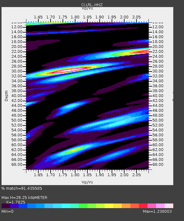
| Estimated Moho Depth: |
29.25 km |
| Estimated Crust Vp/Vs: |
1.78 |
| Assumed Crust Vp: |
6.276 km/s |
| Estimated Crust Vs: |
3.521 km/s |
| Estimated Crust Poisson's Ratio: |
0.27 |
|
| Radial Match: |
91.435585 % |
| Radial Bump: |
400 |
| Transverse Match: |
77.79031 % |
| Transverse Bump: |
400 |
| SOD ConfigId: |
22732711 |
| Insert Time: |
2020-09-29 03:47:53.409 +0000 |
| GWidth: |
2.5 |
| Max Bumps: |
400 |
| Tol: |
0.001 |
|
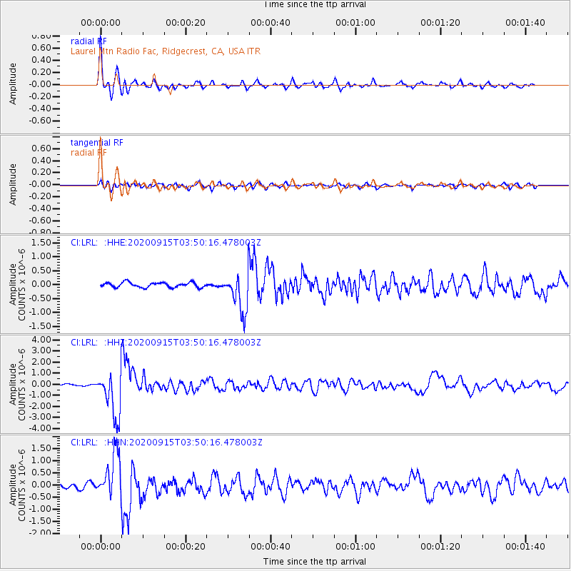
Signal To Noise
| Channel | StoN | STA | LTA |
| CI:LRL: :HHZ:20200915T03:50:16.478003Z | 30.999279 | 2.0898801E-6 | 6.7417055E-8 |
| CI:LRL: :HHN:20200915T03:50:16.478003Z | 11.034016 | 9.357094E-7 | 8.480226E-8 |
| CI:LRL: :HHE:20200915T03:50:16.478003Z | 8.377811 | 7.313097E-7 | 8.7291255E-8 |
| Arrivals |
| Ps | 3.8 SECOND |
| PpPs | 12 SECOND |
| PsPs/PpSs | 16 SECOND |


