You are here: Home > Network List > CI - Caltech Regional Seismic Network Stations List
> Station SMM Simmler, CA, USA > Earthquake Result Viewer
SMM Simmler, CA, USA - Earthquake Result Viewer
| Earthquake location: |
Kamchatka Peninsula, Russia |
| Earthquake latitude/longitude: |
55.9/158.5 |
| Earthquake time(UTC): |
2020/09/15 (259) 03:41:28 GMT |
| Earthquake Depth: |
344 km |
| Earthquake Magnitude: |
6.4 Mww |
| Earthquake Catalog/Contributor: |
NEIC PDE/us |
|
| Network: |
CI Caltech Regional Seismic Network |
| Station: |
SMM Simmler, CA, USA |
| Lat/Lon: |
35.31 N/120.00 W |
| Elevation: |
599 m |
|
| Distance: |
57.1 deg |
| Az: |
74.485 deg |
| Baz: |
318.461 deg |
| Ray Param: |
0.062475577 |
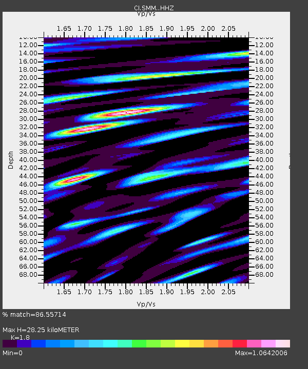
| Estimated Moho Depth: |
28.25 km |
| Estimated Crust Vp/Vs: |
1.80 |
| Assumed Crust Vp: |
6.1 km/s |
| Estimated Crust Vs: |
3.389 km/s |
| Estimated Crust Poisson's Ratio: |
0.28 |
|
| Radial Match: |
86.55714 % |
| Radial Bump: |
400 |
| Transverse Match: |
81.25012 % |
| Transverse Bump: |
400 |
| SOD ConfigId: |
22732711 |
| Insert Time: |
2020-09-29 03:48:27.768 +0000 |
| GWidth: |
2.5 |
| Max Bumps: |
400 |
| Tol: |
0.001 |
|
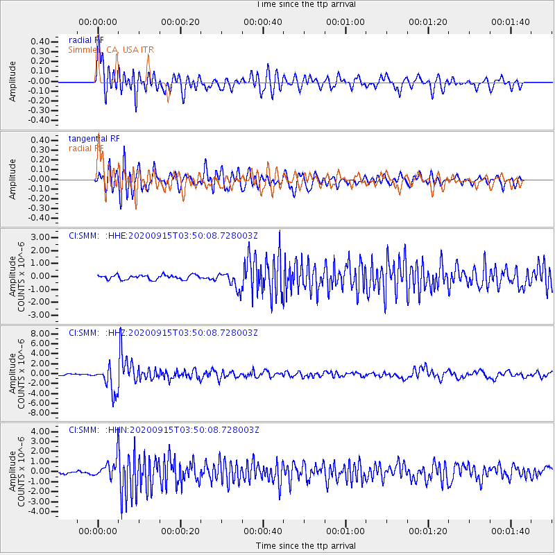
Signal To Noise
| Channel | StoN | STA | LTA |
| CI:SMM: :HHZ:20200915T03:50:08.728003Z | 23.835285 | 2.7045323E-6 | 1.13467586E-7 |
| CI:SMM: :HHN:20200915T03:50:08.728003Z | 7.6142554 | 1.010748E-6 | 1.3274415E-7 |
| CI:SMM: :HHE:20200915T03:50:08.728003Z | 4.000152 | 6.928645E-7 | 1.7320953E-7 |
| Arrivals |
| Ps | 3.9 SECOND |
| PpPs | 12 SECOND |
| PsPs/PpSs | 16 SECOND |


