You are here: Home > Network List > AT - Alaska Tsunami Warning Seismic System Stations List
> Station SVW2 Sparrevohn, Alaska > Earthquake Result Viewer
SVW2 Sparrevohn, Alaska - Earthquake Result Viewer
| Earthquake location: |
Banda Sea |
| Earthquake latitude/longitude: |
-6.1/130.4 |
| Earthquake time(UTC): |
2009/10/24 (297) 14:40:43 GMT |
| Earthquake Depth: |
130 km |
| Earthquake Magnitude: |
6.7 MB, 6.9 MW, 6.9 MW |
| Earthquake Catalog/Contributor: |
WHDF/NEIC |
|
| Network: |
AT Alaska Tsunami Warning Seismic System |
| Station: |
SVW2 Sparrevohn, Alaska |
| Lat/Lon: |
61.11 N/155.62 W |
| Elevation: |
499 m |
|
| Distance: |
87.7 deg |
| Az: |
27.853 deg |
| Baz: |
253.054 deg |
| Ray Param: |
0.042859524 |
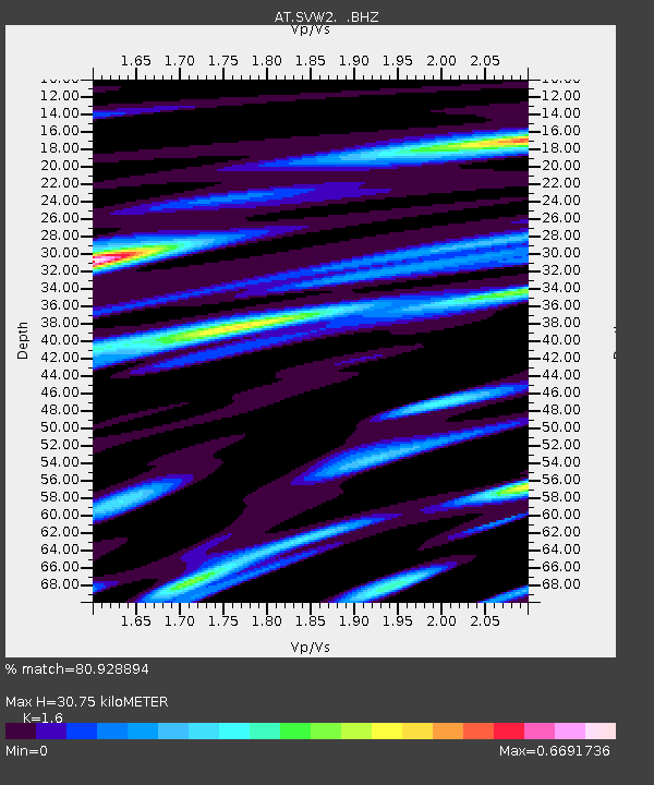
| Estimated Moho Depth: |
30.75 km |
| Estimated Crust Vp/Vs: |
1.60 |
| Assumed Crust Vp: |
6.566 km/s |
| Estimated Crust Vs: |
4.104 km/s |
| Estimated Crust Poisson's Ratio: |
0.18 |
|
| Radial Match: |
80.928894 % |
| Radial Bump: |
339 |
| Transverse Match: |
64.548874 % |
| Transverse Bump: |
400 |
| SOD ConfigId: |
2622 |
| Insert Time: |
2010-03-09 01:15:36.194 +0000 |
| GWidth: |
2.5 |
| Max Bumps: |
400 |
| Tol: |
0.001 |
|

Signal To Noise
| Channel | StoN | STA | LTA |
| AT:SVW2: :BHZ:20091024T14:52:46.459014Z | 2.0044582 | 1.0058266E-6 | 5.017947E-7 |
| AT:SVW2: :BHN:20091024T14:52:46.459014Z | 1.1096425 | 3.2328768E-7 | 2.9134398E-7 |
| AT:SVW2: :BHE:20091024T14:52:46.459014Z | 0.98306113 | 2.8656476E-7 | 2.915025E-7 |
| Arrivals |
| Ps | 2.9 SECOND |
| PpPs | 12 SECOND |
| PsPs/PpSs | 15 SECOND |


