You are here: Home > Network List > G - GEOSCOPE Stations List
> Station NOUC Port Laguerre, New Caledonia > Earthquake Result Viewer
NOUC Port Laguerre, New Caledonia - Earthquake Result Viewer

| Earthquake location: |
Southern Sumatra, Indonesia |
| Earthquake latitude/longitude: |
-3.8/101.6 |
| Earthquake time(UTC): |
2017/08/13 (225) 03:08:11 GMT |
| Earthquake Depth: |
36 km |
| Earthquake Magnitude: |
6.4 Mww |
| Earthquake Catalog/Contributor: |
NEIC PDE/us |
|
| Network: |
G GEOSCOPE |
| Station: |
NOUC Port Laguerre, New Caledonia |
| Lat/Lon: |
22.10 S/166.30 E |
| Elevation: |
112 m |
|
| Distance: |
65.2 deg |
| Az: |
112.495 deg |
| Baz: |
276.234 deg |
| Ray Param: |
0.05839082 |
| Estimated Moho Depth: |
51.0 km |
| Estimated Crust Vp/Vs: |
2.09 |
| Assumed Crust Vp: |
5.14 km/s |
| Estimated Crust Vs: |
2.456 km/s |
| Estimated Crust Poisson's Ratio: |
0.35 |
|
| Radial Match: |
84.719055 % |
| Radial Bump: |
400 |
| Transverse Match: |
85.2968 % |
| Transverse Bump: |
400 |
| SOD ConfigId: |
2140511 |
| Insert Time: |
2017-08-26 19:00:15.059 +0000 |
| GWidth: |
2.5 |
| Max Bumps: |
400 |
| Tol: |
0.001 |
|
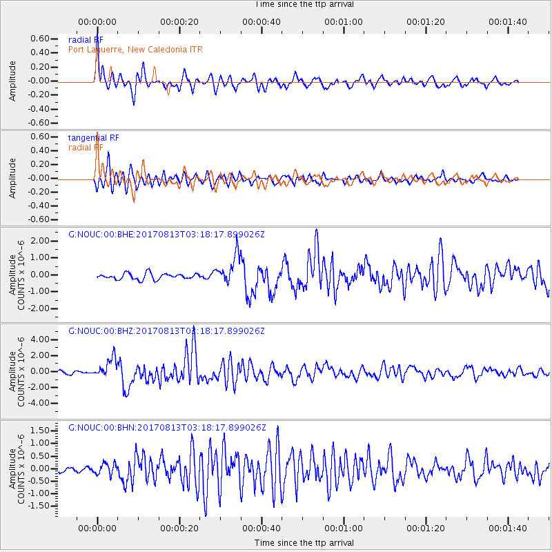
Signal To Noise
| Channel | StoN | STA | LTA |
| G:NOUC:00:BHZ:20170813T03:18:17.899026Z | 6.420336 | 1.2710196E-6 | 1.9796778E-7 |
| G:NOUC:00:BHN:20170813T03:18:17.899026Z | 1.6443193 | 2.1752875E-7 | 1.3229108E-7 |
| G:NOUC:00:BHE:20170813T03:18:17.899026Z | 4.9367924 | 8.794189E-7 | 1.7813568E-7 |
| Arrivals |
| Ps | 11 SECOND |
| PpPs | 30 SECOND |
| PsPs/PpSs | 41 SECOND |


