You are here: Home > Network List > N4 - Central and EAstern US Network Stations List
> Station I37B Waseca, MN, USA > Earthquake Result Viewer
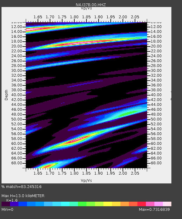
I37B Waseca, MN, USA - Earthquake Result Viewer
| Earthquake location: |
Kamchatka Peninsula, Russia |
| Earthquake latitude/longitude: |
55.9/158.5 |
| Earthquake time(UTC): |
2020/09/15 (259) 03:41:28 GMT |
| Earthquake Depth: |
344 km |
| Earthquake Magnitude: |
6.4 Mww |
| Earthquake Catalog/Contributor: |
NEIC PDE/us |
|
| Network: |
N4 Central and EAstern US Network |
| Station: |
I37B Waseca, MN, USA |
| Lat/Lon: |
44.01 N/93.40 W |
| Elevation: |
354 m |
|
| Distance: |
63.5 deg |
| Az: |
49.992 deg |
| Baz: |
323.307 deg |
| Ray Param: |
0.058388535 |
| Estimated Moho Depth: |
13.0 km |
| Estimated Crust Vp/Vs: |
1.60 |
| Assumed Crust Vp: |
6.571 km/s |
| Estimated Crust Vs: |
4.107 km/s |
| Estimated Crust Poisson's Ratio: |
0.18 |
|
| Radial Match: |
83.245316 % |
| Radial Bump: |
400 |
| Transverse Match: |
60.246475 % |
| Transverse Bump: |
400 |
| SOD ConfigId: |
22732711 |
| Insert Time: |
2020-09-29 03:59:14.339 +0000 |
| GWidth: |
2.5 |
| Max Bumps: |
400 |
| Tol: |
0.001 |
|

Signal To Noise
| Channel | StoN | STA | LTA |
| N4:I37B:00:HHZ:20200915T03:50:51.788978Z | 14.903484 | 4.4423E-6 | 2.9807123E-7 |
| N4:I37B:00:HH1:20200915T03:50:51.788978Z | 2.661105 | 8.543128E-7 | 3.2103688E-7 |
| N4:I37B:00:HH2:20200915T03:50:51.788978Z | 4.5133877 | 9.963568E-7 | 2.2075585E-7 |
| Arrivals |
| Ps | 1.2 SECOND |
| PpPs | 4.9 SECOND |
| PsPs/PpSs | 6.1 SECOND |


