You are here: Home > Network List > NM - Cooperative New Madrid Seismic Network Stations List
> Station LPAR Lepanto,AR > Earthquake Result Viewer
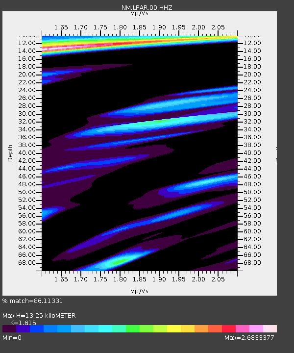
LPAR Lepanto,AR - Earthquake Result Viewer
| Earthquake location: |
Kamchatka Peninsula, Russia |
| Earthquake latitude/longitude: |
55.9/158.5 |
| Earthquake time(UTC): |
2020/09/15 (259) 03:41:28 GMT |
| Earthquake Depth: |
344 km |
| Earthquake Magnitude: |
6.4 Mww |
| Earthquake Catalog/Contributor: |
NEIC PDE/us |
|
| Network: |
NM Cooperative New Madrid Seismic Network |
| Station: |
LPAR Lepanto,AR |
| Lat/Lon: |
35.60 N/90.30 W |
| Elevation: |
67 m |
|
| Distance: |
71.8 deg |
| Az: |
53.099 deg |
| Baz: |
326.475 deg |
| Ray Param: |
0.053087037 |
| Estimated Moho Depth: |
13.25 km |
| Estimated Crust Vp/Vs: |
1.62 |
| Assumed Crust Vp: |
6.273 km/s |
| Estimated Crust Vs: |
3.884 km/s |
| Estimated Crust Poisson's Ratio: |
0.19 |
|
| Radial Match: |
86.11331 % |
| Radial Bump: |
308 |
| Transverse Match: |
45.838787 % |
| Transverse Bump: |
340 |
| SOD ConfigId: |
22732711 |
| Insert Time: |
2020-09-29 04:02:10.414 +0000 |
| GWidth: |
2.5 |
| Max Bumps: |
400 |
| Tol: |
0.001 |
|

Signal To Noise
| Channel | StoN | STA | LTA |
| NM:LPAR:00:HHZ:20200915T03:51:42.730018Z | 30.125998 | 8.616129E-6 | 2.8600311E-7 |
| NM:LPAR:00:HHN:20200915T03:51:42.730018Z | 3.018257 | 2.5564698E-6 | 8.4700207E-7 |
| NM:LPAR:00:HHE:20200915T03:51:42.730018Z | 2.24206 | 1.72664E-6 | 7.701133E-7 |
| Arrivals |
| Ps | 1.3 SECOND |
| PpPs | 5.3 SECOND |
| PsPs/PpSs | 6.7 SECOND |


