You are here: Home > Network List > O2 - Oklahoma Consolidated Temporary Seismic Networks Stations List
> Station SC16 Oakwood, Oklahoma, USA > Earthquake Result Viewer
SC16 Oakwood, Oklahoma, USA - Earthquake Result Viewer
| Earthquake location: |
Kamchatka Peninsula, Russia |
| Earthquake latitude/longitude: |
55.9/158.5 |
| Earthquake time(UTC): |
2020/09/15 (259) 03:41:28 GMT |
| Earthquake Depth: |
344 km |
| Earthquake Magnitude: |
6.4 Mww |
| Earthquake Catalog/Contributor: |
NEIC PDE/us |
|
| Network: |
O2 Oklahoma Consolidated Temporary Seismic Networks |
| Station: |
SC16 Oakwood, Oklahoma, USA |
| Lat/Lon: |
35.97 N/98.82 W |
| Elevation: |
500 m |
|
| Distance: |
67.5 deg |
| Az: |
58.919 deg |
| Baz: |
323.54 deg |
| Ray Param: |
0.055847295 |
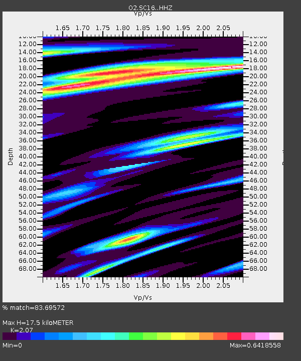
| Estimated Moho Depth: |
17.5 km |
| Estimated Crust Vp/Vs: |
2.07 |
| Assumed Crust Vp: |
6.315 km/s |
| Estimated Crust Vs: |
3.051 km/s |
| Estimated Crust Poisson's Ratio: |
0.35 |
|
| Radial Match: |
83.69572 % |
| Radial Bump: |
400 |
| Transverse Match: |
59.41975 % |
| Transverse Bump: |
400 |
| SOD ConfigId: |
22732711 |
| Insert Time: |
2020-09-29 04:04:55.569 +0000 |
| GWidth: |
2.5 |
| Max Bumps: |
400 |
| Tol: |
0.001 |
|

Signal To Noise
| Channel | StoN | STA | LTA |
| O2:SC16: :HHZ:20200915T03:51:16.92002Z | 10.089521 | 2.4387512E-6 | 2.417113E-7 |
| O2:SC16: :HHN:20200915T03:51:16.92002Z | 3.7892742 | 7.5462737E-7 | 1.9914826E-7 |
| O2:SC16: :HHE:20200915T03:51:16.92002Z | 1.7515895 | 4.1557857E-7 | 2.3725796E-7 |
| Arrivals |
| Ps | 3.1 SECOND |
| PpPs | 8.2 SECOND |
| PsPs/PpSs | 11 SECOND |


