You are here: Home > Network List > O2 - Oklahoma Consolidated Temporary Seismic Networks Stations List
> Station SC02 Maysville, Garvin & McClain Counties, OK, USA > Earthquake Result Viewer
SC02 Maysville, Garvin & McClain Counties, OK, USA - Earthquake Result Viewer
| Earthquake location: |
Kamchatka Peninsula, Russia |
| Earthquake latitude/longitude: |
55.9/158.5 |
| Earthquake time(UTC): |
2020/09/15 (259) 03:41:28 GMT |
| Earthquake Depth: |
344 km |
| Earthquake Magnitude: |
6.4 Mww |
| Earthquake Catalog/Contributor: |
NEIC PDE/us |
|
| Network: |
O2 Oklahoma Consolidated Temporary Seismic Networks |
| Station: |
SC02 Maysville, Garvin & McClain Counties, OK, USA |
| Lat/Lon: |
34.80 N/97.39 W |
| Elevation: |
310 m |
|
| Distance: |
69.1 deg |
| Az: |
58.651 deg |
| Baz: |
324.263 deg |
| Ray Param: |
0.05479822 |
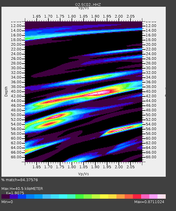
| Estimated Moho Depth: |
40.5 km |
| Estimated Crust Vp/Vs: |
1.91 |
| Assumed Crust Vp: |
6.426 km/s |
| Estimated Crust Vs: |
3.369 km/s |
| Estimated Crust Poisson's Ratio: |
0.31 |
|
| Radial Match: |
84.37576 % |
| Radial Bump: |
353 |
| Transverse Match: |
74.87277 % |
| Transverse Bump: |
400 |
| SOD ConfigId: |
22732711 |
| Insert Time: |
2020-09-29 04:05:07.064 +0000 |
| GWidth: |
2.5 |
| Max Bumps: |
400 |
| Tol: |
0.001 |
|

Signal To Noise
| Channel | StoN | STA | LTA |
| O2:SC02: :HHZ:20200915T03:51:26.944983Z | 24.434341 | 3.7749892E-6 | 1.5449523E-7 |
| O2:SC02: :HHN:20200915T03:51:26.944983Z | 4.0955806 | 1.0543663E-6 | 2.5744E-7 |
| O2:SC02: :HHE:20200915T03:51:26.944983Z | 4.114043 | 9.581348E-7 | 2.3289373E-7 |
| Arrivals |
| Ps | 5.9 SECOND |
| PpPs | 18 SECOND |
| PsPs/PpSs | 24 SECOND |


