You are here: Home > Network List > UO - University of Oregon Regional Network Stations List
> Station EUO Eugene,OR U0 CREST BB SMO > Earthquake Result Viewer
EUO Eugene,OR U0 CREST BB SMO - Earthquake Result Viewer
| Earthquake location: |
Tonga Islands |
| Earthquake latitude/longitude: |
-21.9/-173.8 |
| Earthquake time(UTC): |
2008/10/19 (293) 05:10:33 GMT |
| Earthquake Depth: |
29 km |
| Earthquake Magnitude: |
6.8 MB, 7.0 MS, 6.9 MW, 6.9 MW |
| Earthquake Catalog/Contributor: |
WHDF/NEIC |
|
| Network: |
UO University of Oregon Regional Network |
| Station: |
EUO Eugene,OR U0 CREST BB SMO |
| Lat/Lon: |
44.03 N/123.07 W |
| Elevation: |
160 m |
|
| Distance: |
80.4 deg |
| Az: |
34.512 deg |
| Baz: |
226.859 deg |
| Ray Param: |
0.048295543 |
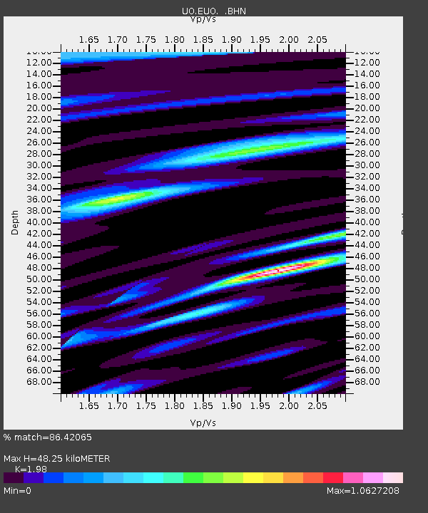
| Estimated Moho Depth: |
48.25 km |
| Estimated Crust Vp/Vs: |
1.98 |
| Assumed Crust Vp: |
6.566 km/s |
| Estimated Crust Vs: |
3.316 km/s |
| Estimated Crust Poisson's Ratio: |
0.33 |
|
| Radial Match: |
86.42065 % |
| Radial Bump: |
400 |
| Transverse Match: |
71.853874 % |
| Transverse Bump: |
400 |
| SOD ConfigId: |
2556 |
| Insert Time: |
2010-03-09 01:17:16.065 +0000 |
| GWidth: |
2.5 |
| Max Bumps: |
400 |
| Tol: |
0.001 |
|

Signal To Noise
| Channel | StoN | STA | LTA |
| UO:EUO: :BHN:20081019T05:22:11.175015Z | 31.035707 | 8.097655E-6 | 2.6091416E-7 |
| UO:EUO: :BHE:20081019T05:22:11.175015Z | 4.91921 | 1.8068131E-6 | 3.6729742E-7 |
| UO:EUO: :BHZ:20081019T05:22:11.175015Z | 5.258409 | 2.1221201E-6 | 4.0356696E-7 |
| Arrivals |
| Ps | 7.4 SECOND |
| PpPs | 21 SECOND |
| PsPs/PpSs | 29 SECOND |


