You are here: Home > Network List > TX - Texas Seismological Network Stations List
> Station 833A Chaparral WMA, Artesia Wells, TX, USA > Earthquake Result Viewer
833A Chaparral WMA, Artesia Wells, TX, USA - Earthquake Result Viewer
| Earthquake location: |
Kamchatka Peninsula, Russia |
| Earthquake latitude/longitude: |
55.9/158.5 |
| Earthquake time(UTC): |
2020/09/15 (259) 03:41:28 GMT |
| Earthquake Depth: |
344 km |
| Earthquake Magnitude: |
6.4 Mww |
| Earthquake Catalog/Contributor: |
NEIC PDE/us |
|
| Network: |
TX Texas Seismological Network |
| Station: |
833A Chaparral WMA, Artesia Wells, TX, USA |
| Lat/Lon: |
28.32 N/99.39 W |
| Elevation: |
171 m |
|
| Distance: |
73.4 deg |
| Az: |
64.07 deg |
| Baz: |
324.96 deg |
| Ray Param: |
0.052020695 |
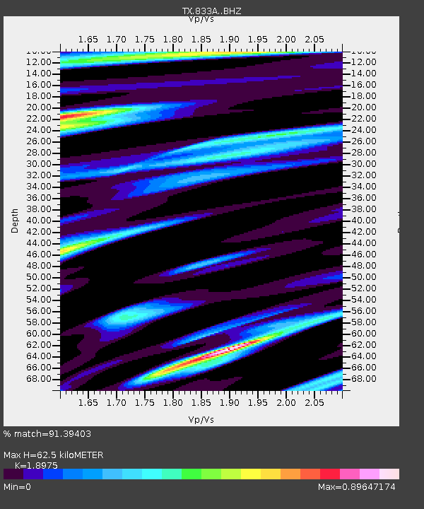
| Estimated Moho Depth: |
62.5 km |
| Estimated Crust Vp/Vs: |
1.90 |
| Assumed Crust Vp: |
6.347 km/s |
| Estimated Crust Vs: |
3.345 km/s |
| Estimated Crust Poisson's Ratio: |
0.31 |
|
| Radial Match: |
91.39403 % |
| Radial Bump: |
400 |
| Transverse Match: |
91.98454 % |
| Transverse Bump: |
337 |
| SOD ConfigId: |
22732711 |
| Insert Time: |
2020-09-29 04:10:57.163 +0000 |
| GWidth: |
2.5 |
| Max Bumps: |
400 |
| Tol: |
0.001 |
|

Signal To Noise
| Channel | StoN | STA | LTA |
| TX:833A: :BHZ:20200915T03:51:52.249976Z | 12.528651 | 1.2925402E-6 | 1.0316675E-7 |
| TX:833A: :BHN:20200915T03:51:52.249976Z | 3.7142706 | 4.8960874E-7 | 1.3181827E-7 |
| TX:833A: :BHE:20200915T03:51:52.249976Z | 11.532623 | 8.930264E-7 | 7.7434805E-8 |
| Arrivals |
| Ps | 9.1 SECOND |
| PpPs | 28 SECOND |
| PsPs/PpSs | 37 SECOND |


