You are here: Home > Network List > TX - Texas Seismological Network Stations List
> Station PB21 Reeves Ward Border > Earthquake Result Viewer
PB21 Reeves Ward Border - Earthquake Result Viewer
| Earthquake location: |
Kamchatka Peninsula, Russia |
| Earthquake latitude/longitude: |
55.9/158.5 |
| Earthquake time(UTC): |
2020/09/15 (259) 03:41:28 GMT |
| Earthquake Depth: |
344 km |
| Earthquake Magnitude: |
6.4 Mww |
| Earthquake Catalog/Contributor: |
NEIC PDE/us |
|
| Network: |
TX Texas Seismological Network |
| Station: |
PB21 Reeves Ward Border |
| Lat/Lon: |
31.34 N/103.06 W |
| Elevation: |
753 m |
|
| Distance: |
69.1 deg |
| Az: |
64.942 deg |
| Baz: |
323.424 deg |
| Ray Param: |
0.05481866 |
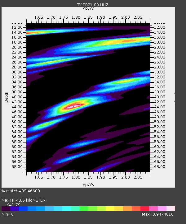
| Estimated Moho Depth: |
43.5 km |
| Estimated Crust Vp/Vs: |
1.79 |
| Assumed Crust Vp: |
6.121 km/s |
| Estimated Crust Vs: |
3.419 km/s |
| Estimated Crust Poisson's Ratio: |
0.27 |
|
| Radial Match: |
89.46688 % |
| Radial Bump: |
344 |
| Transverse Match: |
80.86785 % |
| Transverse Bump: |
400 |
| SOD ConfigId: |
22732711 |
| Insert Time: |
2020-09-29 04:12:11.245 +0000 |
| GWidth: |
2.5 |
| Max Bumps: |
400 |
| Tol: |
0.001 |
|

Signal To Noise
| Channel | StoN | STA | LTA |
| TX:PB21:00:HHZ:20200915T03:51:26.759986Z | 16.63009 | 2.195815E-6 | 1.3203865E-7 |
| TX:PB21:00:HH1:20200915T03:51:26.759986Z | 8.0022 | 7.7355105E-7 | 9.666729E-8 |
| TX:PB21:00:HH2:20200915T03:51:26.759986Z | 3.5624375 | 3.2399083E-7 | 9.094639E-8 |
| Arrivals |
| Ps | 5.8 SECOND |
| PpPs | 19 SECOND |
| PsPs/PpSs | 25 SECOND |


