You are here: Home > Network List > TX - Texas Seismological Network Stations List
> Station PB29 Culberson North > Earthquake Result Viewer
PB29 Culberson North - Earthquake Result Viewer
| Earthquake location: |
Kamchatka Peninsula, Russia |
| Earthquake latitude/longitude: |
55.9/158.5 |
| Earthquake time(UTC): |
2020/09/15 (259) 03:41:28 GMT |
| Earthquake Depth: |
344 km |
| Earthquake Magnitude: |
6.4 Mww |
| Earthquake Catalog/Contributor: |
NEIC PDE/us |
|
| Network: |
TX Texas Seismological Network |
| Station: |
PB29 Culberson North |
| Lat/Lon: |
31.75 N/104.51 W |
| Elevation: |
1242 m |
|
| Distance: |
68.0 deg |
| Az: |
65.745 deg |
| Baz: |
322.961 deg |
| Ray Param: |
0.055501886 |
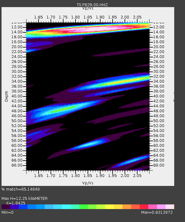
| Estimated Moho Depth: |
12.25 km |
| Estimated Crust Vp/Vs: |
1.84 |
| Assumed Crust Vp: |
6.361 km/s |
| Estimated Crust Vs: |
3.452 km/s |
| Estimated Crust Poisson's Ratio: |
0.29 |
|
| Radial Match: |
85.14848 % |
| Radial Bump: |
384 |
| Transverse Match: |
58.53814 % |
| Transverse Bump: |
374 |
| SOD ConfigId: |
22732711 |
| Insert Time: |
2020-09-29 04:12:14.066 +0000 |
| GWidth: |
2.5 |
| Max Bumps: |
400 |
| Tol: |
0.001 |
|

Signal To Noise
| Channel | StoN | STA | LTA |
| TX:PB29:00:HHZ:20200915T03:51:20.209998Z | 8.1111 | 2.2313625E-6 | 2.7509986E-7 |
| TX:PB29:00:HH1:20200915T03:51:20.209998Z | 2.307046 | 6.284435E-7 | 2.7240182E-7 |
| TX:PB29:00:HH2:20200915T03:51:20.209998Z | 4.763324 | 6.553778E-7 | 1.3758833E-7 |
| Arrivals |
| Ps | 1.7 SECOND |
| PpPs | 5.3 SECOND |
| PsPs/PpSs | 7.0 SECOND |


